Upton Snodsbury Circular
Worcestershire Walk
County/Area - Worcestershire
Author - Millennium Way
Length - 7.5 miles / 12.2 km Ascent - 335 feet / 102 metres
Time - 4 hours 10 minutes Grade - easy/mod
Walk Route Description
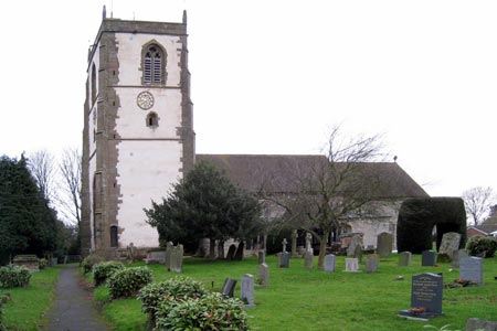
Click image to visit gallery of 2 images.
The circular Worcestershire walk crosses mostly flat, open countryside through farmland but with several stiles. During the early part of the walk, between Upton Snodsbury and Flyford Flavell you will enjoy a delightful section of the Millennium Way with the route clearly marked by the distinctive green waymarkers. (Further information) Nestling between low hills amidst farmland, the pretty parish of Upton Snodsbury lies 7 miles east of Worcester along the A422. The church is dedicated to St. Kenelm and includes some fine stained glass windows, including several from the 1960s and 1970s designed by Francis Keat.
A - We start our walk from the Car Park of The Oak (More information) where you may park providing you take refreshment at the end of the walk. Take the stile in the far corner of the car park then go half left up the field to take metal kissing gate, then go diagonally left across next field heading towards the church. Take the gate ahead where you will see the first green Millennium Way waymarker. Continue past school on your right, down to main road (Upton Snodsbury Church is on the left.) Cross road and take the alleyway between houses to field and go with hedge left for 200m then cross field and ditch to take mid fence stile ahead. Go half right across field and when you reach hedge, bear left keeping hedge right through two fields to corner stile and road.
B - Cross road to take gap in hedge going through scrub and continue with river left to driveway left to bridge gate. Go half right to field corner single tree then go left with hedge right around field corner to take gap ahead between tall hedges. Enter left field and head directly past mid field double power poles towards hedge ahead, then go a few paces left along hedge to find gated hedge gap. Take gap and go ahead through plantation to gate onto road. Cross road, go through gate and after 12 paces keep slightly right where paths diverge through a short avenue of trees eventually emerging to cross track & wooden footbridge and stile. Continue ahead through copse between two barbed wire fences (small pond on left ) and exit by stile to cross field ahead to take mid hedge kissing gate to road.
C - Go left on road to go over crossroads at North Piddle and continue up road passing Moat House on your right. After some 250 paces take signed footpath in fence gap right. Go up slope with hedge right to take double fence stile then ahead with hedge right to exit field by stile. Go ahead with hedge right to take kissing gate, then go immediately right to take further kissing gate. Go left with hedge left to take far corner gate then ahead across next field to take metal kissing gate (Ignore stile R.) Go half left up next field towards tower of Flyford Flavell church and exit field by right hand of two stiles to go left around paddock towards the church passing between two dew ponds. Take the next two stiles, past the tennis court and go left on driveway into Flyford Flavell.
D - Go right on road passing Flyford stores, then just past the Boot Inn take the signed footpath left. (Here we leave the Millennium Way and join the Wychavon Way) Go over the stile then half left under power lines and take wooden gate at top of field. Continue diagonally across grassed area to take corner metal gate to field. Go ahead with hedge left to take gap then downhill following power lines to reach main road. Cross main road to take metal gate then footbridge ahead. Go left to cross stile then take footpath right ( Wychaven Way .) Go gently uphill with hedge right and find stile right. Take stile to go left up drive to go over cattle grid to turn right in front of house then over grassed area to take stile right to go left with hedge left towards Grafton Wood ahead. Continue along edge of wood to take metal kissing gate left into wood. (Here we leave the Wychavon Way to enter the wood which is a butterfly conservation area affiliated to the Worcestershire Wildlife Trust.)
E - Maintain your line ahead through wood to exit by large metal gate at the end of the track. Go half right diagonally across next field to go through waymarked gap ahead and after a few paces to take gap left to continue right up field with hedge right as waymarked. Soon we can see Grafton Flyford church ahead. Continue along edge of field towards farm buildings to exit via large metal gate. Go through farmyard with buildings left, through next gate and down drive towards the church. After passing the church ignore footpath left and continue right down track passing the old rectory to reach the road.
F - Turn left at road then immediately right through gate to field keeping ahead with hedge right. Take corner gap then go directly ahead across centre of two fields to reach footbridge
Go over footbridge then go left with hedge left until you come to gap. Go R here and head up field towards double power lines keeping hedge left. Go under power lines towards barns. Turn right on reaching farm track to reach public footpath sign ahead. Go left here passing barn right, go through large metal gate and continue ahead with hedge left, ignoring stile left. Stay ahead to cross next stile towards wood, crossing double stile in top corner of field then going half right in next field towards corner of wood. As you reach the corner take the gate directly ahead, ignoring the stile to your the right.
G - Go ahead through next large gate into field and go with wood left. At the next waypoint go through gap and take bridleway half left, keeping edge of wood on your left and buildings directly ahead. Proceed around edge of field towards buildings and exit to drive through metal gate. Continue down driveway past houses and on reaching the bend, about 100m before stream, go sharp left through large metal gate and up field along bridleway heading towards edge of wood. Go through two metal gates into next field then stay ahead keeping stream to far right. Head towards farm buildings which will soon appear in far distance, then towards corner just to the left of buildings (not the most picturesque of farms) and exit by metal gate down the track to the main road. Turn left to arrive back at The Oak.
Maps 

| Ordnance Survey Explorer 204 | Sheet Map | 1:25k | BUY |
| Anquet OS Explorer 204 | Digital Map | 1:25k | BUY |
| Ordnance Survey Digital Map Subscription | |||
| Latest Ordnance Survey Discounts | |||
Other walks nearby
| Walk 3680 | Broughton Hackett and Upton Snodsbury | easy | 3.0 miles |
| Walk 1313 | White Ladies & Aston circular | easy | 5.5 miles |
| Walk 3692 | Egdon, Stoulton & White Ladies Aston | easy | 6.3 miles |
| Walk 3684 | Flyford Flavell and Dormston circular | easy | 4.5 miles |
| Walk 1355 | Stoulton Circular | easy/mod | 7.5 miles |
| Walk 3226 | New End & Holberrow Green from Inkberrow | easy/mod | 8.0 miles |
| Walk 3686 | Dormston from Inkberrow Circular | easy | 5.4 miles |
| Walk 3715 | Holberrow Green & New End from Inkberrow | easy/mod | 8.3 miles |
| Walk 3502 | Two Rivers Walk to Powick and Worcester | easy | 6.5 miles |
| Walk 3637 | Evesham & Haselor Hill from Cropthorne | easy/mod | 8.0 miles |
