Walk 1036 - printer friendly version
Rhinog Fach & Y Llethr Walk
Author - Peter Smyly
Length - 9.0 miles / 14.6 km
Ascent - 2000 feet / 606 metres
Grade - moderate
Start - OS grid reference SH684302
Lat 52.853164 + Long -3.9558129
Postcode LL41 4YE (approx. location only)
The Rhinog Mountains are perhaps the least visited range in Snowdonia (Eryri) yet they offer some wonderful walking. The main ridge can be divided into two types of terrain with the southernmost section being much less rugged than the northern section. This is a Snowdonia walk that includes two summits - Rhinog Fach with its rugged rocky terrain and the much more rounded and grassy form of Y Llethr, the latter being the highest point in the range.
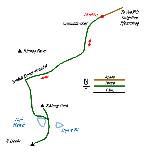
On leaving the car park at Graigddu-isaf (grid ref.SH684302), follow the unsurfaced road to the south west. You soon come to a sign for a footpath through the forest to the right which leads to Bwlch Tyddiad at the top of the Roman Steps but this is not the route for this walk. Instead, keep going straight ahead and follow the road through the trees as it swings round to the right. The key to the route is to take a path that branches off the main track to the right through the trees which leads to a gate that marks the point where the path leaves the forest and emerges onto open fellside (grid ref. SH670285). The two Rhinogs, Rhinog Fach to the left and Rhinog Fawr to the right now appear ahead and the path that cleaves the two reaches its highest point at a large cairn at the top of Bwlch Drws Ardudwy (grid ref. SH684281), the gateway of Ardudwy. It is worth stopping at this point to take in the wild and rugged surroundings with the two Rhinog mountains now towering ahead, one either side.
The path now descends to an amphitheatre type area and a wooden stile over a dry stone wall appears on the left. After crossing the stile, follow the narrow path on the other side of the wall up through the heathery slopes and the small mountain lake of Llyn Cwmhosan soon appears on the left. Its rocky shore presents an attractive foreground to a view looking back towards Rhinog Fawr. The path ahead leads to a larger lake, Llyn Hywel, one of the most picturesque llyns in Snowdonia (Eryri) , set in a wild and rugged cwm with near vertical slabs plunging into the lake on the far side as seen from the outflow.
Rhinog Fach is the mountain that dominates the view on the left, with its shattered crags and slopes of screes and boulders. But fear not, for there is a clear route to the top. Follow the shore of Llyn Hywel to the left of the outflow and the path leads up to the bwlch where another lake, Llyn y Bi (Magpie Lake), comes into view below on the other side. Now head up the steep, rugged path to the left, which leads all the way to the top of Rhinog Fach. The top offers airy views, none more dramatic than that of Llyn Hywel below with another lake, Llyn Perfeddau, beyond.
Now descend again to the bwlch and follow the route ahead to climb steeply up the rocky slope of Y Llethr. Although Y Llethr is the highest peak in the Rhinogs, the summit may well come as something of a disappointment, especially given the rocky, rugged terrain experienced thus far on the walk. The highest point is marked by a small pile of stones on a broad, flattish grassy area with a dry stone wall to one side.
Return to Llyn Hywel by following the grassy, pathless slope of Y Llethr, then the rest of the walk involves doing the outgoing route in reverse back to the car park.
Messaging & Social Media
Message Walking Britain and follow the latest news.

Mountain Weather
Stay safe on the mountains with detailed weather forecasts - for iOS devices or for Android devices.