Walk 1050 - printer friendly version
Highcliff Nab & Roseberry Topping from Slapewath Walk
Author - Andy Chaplin
Length - 10.5 miles / 17.1 km
Ascent - 1000 feet / 303 metres
Grade - moderate
Start - OS grid reference NZ643158
Lat 54.533402 + Long -1.0078419
Postcode TS14 6PX (approx. location only)
This North York Moors walk explores a section of the Cleveland Way and incorporates two outstanding features on the northern flank of the National Park. Generally route finding is straightforward although it can occasionally be a little wet underfoot. Despite the route being close to the industrial sprawl of Teesside it does not have any impact on the quality of walking. Chose a fine day and enjoy this wonderful section of countryside.
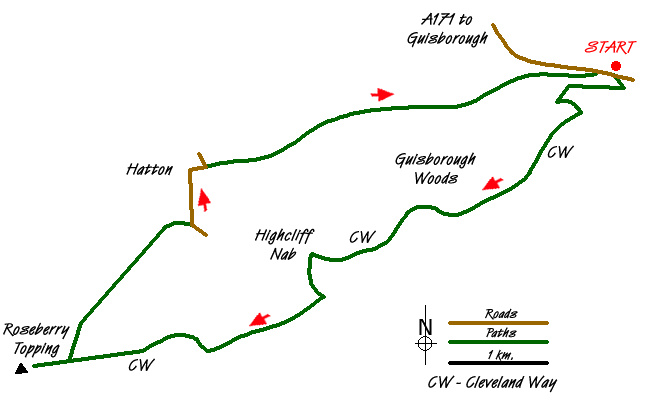
From the parking either in the road outside the Fox & Hounds at Slapewath (Grid ref. NZ643158) or the car park on the opposite side of the A171, follow the Cleveland Way westwards to Highcliff Nab. Guisborough Woods are mainly felled at the moment (2013) so the walking is more open than it would appear from the OS maps although there are some diversions where the foresters are still working.
From Highcliff Nab you get great views - northwards to the coast and maybe less of a great view of the off shore wind-farms and Middlesborough's chemical works! This is also an excellent place to take a break before climbing down southwards, still on the Cleveland Way to walk to the second notable feature of the route. It is a straightforward walk across the moorland to Roseberry Common. For part of the way you follow the boundary between North Yorkshire and Redcar & Cleveland. The Cleveland Way turns south but you continue and climb up Roseberry Topping for the view. This provides another excuse for a break before returning downhill to the Common. Here take the path heading north-east between High Bousdale and Hutton Lowcross woods. The route is well defined an easy to follow and slowly drops down to the road between Hutton Gate and Hutton Village.
Turn left (north) on this road and continue past Hutton Hall to the old railway. This is accessed by a track alongside houses running to a road junction where the access to the railway is some 10 yards down the road heading east. The old railway track bed makes for quick but relatively uninteresting walking. However there are a number of metal artworks alongside the walk and impressive apple tree in open country next to the track which was very abundant in September. No doubt from an apple tossed many years ago from a train. Half a kilometer from Slapewath the railway line passes through a section that is signed as "private land - open to walkers with permission". It continues over the viaduct above a stream on a well-walked path and comes out on the A171 just before the Fox & Hounds.
Messaging & Social Media
Message Walking Britain and follow the latest news.

Mountain Weather
Stay safe on the mountains with detailed weather forecasts - for iOS devices or for Android devices.