Walk 1075 - printer friendly version
High Willhays & Yes Tor Walk
Author - Lou Johnson
Length - 6.5 miles / 10.6 km
Ascent - 1250 feet / 379 metres
Grade - moderate
Start - OS grid reference SX561917
Lat 50.707079 + Long -4.0393299
Postcode SX561917 (approx. location only)
Dartmoor National Park consists of many square miles of open moorland scattered with distinctive rocky tors which are often surrounded by rock strewn slopes. This route takes you to the highest summits in the Dartmoor, which are also the highest south of the Brecon Beacons. Much of Dartmoor is used for military training including the firing of live ammunition so closures are often in place. Before travelling you are advised to contact any of the local Tourist Information Offices to check whether the area being visited is not subject to closure. One word of warning - do not touch any suspicious pieces of military debris.
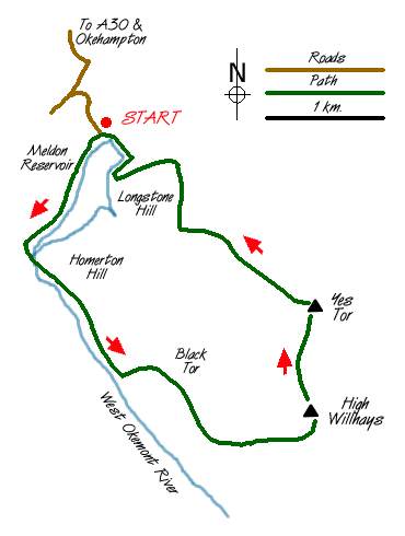
Please Note The concessionary path mentioned in the paragraph below has been blocked by the landowner. This closure prevents access to the northern side of the reservoir. An alternative route avoiding this closure is to cross the dam and take the first path on the right. This leads you along the southern shore of the reservoir to reach the southern side of the footbridge mentioned in the description below. This alternative route is through open access land and should not be subject to closure.
The start is the car park and toilets (Grid ref. 562917) located at the northern end of the dam containing Meldon reservoir. Exit the car park and cross the lane to a signed bridleway heading southwest. Follow this for a short distance turning left along a concessionary footpath that contours across the reservoir side of South Down. Nearing the western end of the reservoir turn left to cross a footbridge. Continue along the eastern side of West Okement river for about one kilometre. Up the slope to your left you will see the rocks of Black Tor, which is your next objective. From here the rocks forming the summit of High Willhays will be obvious lying a further kilometre or so to the east. There are intermittent paths but it is probably better to work your own way through the 'clitter' or rocks which are scattered liberally across the moor.
Reaching the summit of High Willhays (the highest point is on the southernmost rocks) you can proudly claim to the have reached the highest point in England south of Kinder Scout in the Peak District. Despite being inferior in elevation, Yes Tor, roughly a kilometre north, has a trig point and much better view and is easily reached along a clear path. Sadly there is ample evidence of the military presence with some rather shabby buildings scattered across the landscape.
Leaving Yes Tor, the descent is straightforward with a clear path leading you down to the track that skirts the eastern flanks of Longstone Hill. This in turn leads you quickly back to the car park.
Messaging & Social Media
Message Walking Britain and follow the latest news.

Mountain Weather
Stay safe on the mountains with detailed weather forecasts - for iOS devices or for Android devices.