Walk 1089 - printer friendly version
Snowdon by the Pyg and Miner's Tracks Walk
Author - Lou Johnson
Length - 7.5 miles / 12.2 km
Ascent - 2510 feet / 761 metres
Grade - moderate
Start - OS grid reference SH647555
Lat 53.079533 + Long -4.0213041
Postcode LL55 4NU (approx. location only)
Snowdon is a great mountain and despite the summit crowds is well worth climbing. This route must rank as the easiest. Starting at Pen-y-pass means you have considerably reduced the total ascent and with well-maintained paths for most of the way the going is as easy as it gets in these type of surroundings.
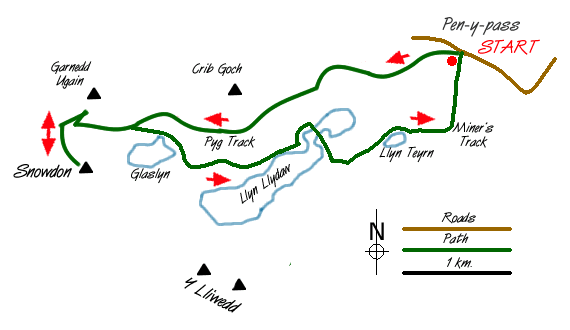
The start for this Snowdonia (Eryri) walk is the car park at Pen-y-pass (grid ref. SH 647555). This car park fills early so the advice is to get there as soon as you can especially when the weather is fine. This route can be attempted in any direction but for the purposes of this description the outward leg uses the Pyg Track with a return along the Miner's Track.
From the car park take the path that exits at the northern end adjacent to the cafe. The first section is dramatic and sets the tone for the whole walk with a great view down to Llanberis. Ahead the east end of Crib Goch can be seen with the great eastern crags of Snowdon leading off to the north. The path climbs steadily to reach a col - Bwlch y Moch - where the path onto Crib Goch leaves to the right.
Staying on the Pyg Track the route continues to climb along the southern flank of Crib Goch with good views right to Llyn Llydaw and Y Lliwedd with Snowdon coming into view ahead. This is some of the grandest mountain scenery in North Wales and despite the steady climb you soon forget the hard work as you enjoy the views. Climbing higher smaller Glaslyn comes into view and it is worth noting where the Miner's Track comes up to meet the path you are on as this will prove useful on the descent.
The relatively easy walk becomes steeper after passing Glaslyn and you climb more rapidly to reach a zigzag which takes you up to a large stone marker at Bwlch Glasw. Again it is worth making a mental note of this for the return journey. You now follow the track of the Snowdon Mountain Railway for the final 300 feet of ascent to the summit.
To return retrace your steps to the stone marker at Bwlch Glasw and descend the zigzag above Glaslyn. You then have a steep descent down to the shores of the lake to join the Miner's Track for the return to Pen-y-pass. Although traversing the same mountainous country the Miner's Track has a different "feel" as the peaks seem higher especially on the section between Glaslyn and Llyn Llydaw. Reaching the shores of the Llyn Llydaw you pass the remains of the mine buildings where Victorian entrepreneurs exploited Snowdon for its copper. Reaching the causeway you can look back to enjoy one of the great views of Snowdon before relaxing on the last almost level stage back to the start.
Messaging & Social Media
Message Walking Britain and follow the latest news.

Mountain Weather
Stay safe on the mountains with detailed weather forecasts - for iOS devices or for Android devices.