Blackwater Reservoir from Kinlochleven
Highland Walk
County/Area - Highland - Fort William Lochaber
Author - Peter Smyly
Length - 11.5 miles / 18.7 km Ascent - 1500 feet / 455 metres
Time - 7 hours 20 minutes Grade - moderate
Walk Route Description
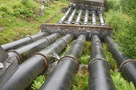
Click image to visit gallery of 6 images.
This walk is a suitable choice for a day when the tops are in cloud, offering a lower level route along one side of the Glen Leven valley, and back along the other side, to complete a circular route. The only minus point is that since the dam of the reservoir is closed to the public, connecting the two sides of the valley involves negotiating a not so pleasant pathless section through undergrowth roughly in parallel to the dam. However it is worth the effort to enable a different return route. The eight mile long Blackwater Reservoir, which was created for hydroelectric power purposes, can be a bleak and desolate place though the walk generally features some waterfalls, a river and a couple of small lochans by way of variety from the woodland trail.
Formerly two smaller villages, modern day Kinlochleven owes its existence to the aluminium works for which it is well-known. From the car park at Kinloch Road, follow the road parallel to the River Leven and cross the first footbridge on the right, signposted for the West Highland Way. Large pipes appear on the right, which connect with a building on top of a wooded hill far off to the left. This landmark seems a long way off at this stage, but it is passed later on in the walk at a key turning point where the route departs from the West Highland Way. Follow the path ahead through deciduous woods uphill before levelling out and emerging into the open. Continue to follow this route as it follows a meandering course, going left down over a bridge and uphill on the other side near a reservoir before you reach the highest point of the water pipes passed earlier in the walk at the bridge. This is the point where the route leaves the West Highland Way (Grid ref. NN202604). The track now makes its way high above the valley on the left with distant views of some of the Mamores peaks beyond.
This section of the route is less frequented now that the West Highland Way has been left behind. By way of variation from the main path to the reservoir, it is soon possible to walk along slabs covering the conduit that contains the outflow of the reservoir with occasional glimpses of rushing water seen between slabs underfoot. The conduit generally keeps the path company. Nearer to the dam, the River Leven follows a meandering course and it goes down by way of a series of waterfalls and passes two small and pretty lakes, the Dubh Lochans. The Blackwater Reservoir's dam is almost a kilometre across (914 metres) and it is the longest in the Scottish Highlands. The conduit comes to an abrupt halt in the form of a wire mesh gate for obvious safety reasons as it is here that the water from the reservoir makes its way in a rushing torrent into a culvert before disappearing from sight underground. This is the point mentioned in the opening paragraph where it is necessary to make your way through a pathless section to join up with the path heading back down the other side of the valley. Crossing the outflow involves finding suitable stepping stones to get across.
Once on the path on the other side of the valley route-finding is easy. The path initially crosses open land with the Dubh Lochans seen clearly on the left before it enters woodland, at one point crossing a bridge to the right over the river. The path leads all the way back to Kinlochleven and the only moments of possible indecision come within a few minutes walk of the return to the bridge crossed early on in the walk where two forks appear in quick succession. Turn left on each occasion and the bridge is soon reached. It is then a simple matter of walking back to the car park along Kinloch Road to return to the walk's start point.
Maps 

| Ordnance Survey Explorer 384 | Sheet Map | 1:25k | BUY |
| Anquet OS Explorer 384 | Digital Map | 1:25k | BUY |
| Ordnance Survey Digital Map Subscription | |||
| Latest Ordnance Survey Discounts | |||
Other walks nearby
| Walk 1496 | WHW - Day 6 - Kinlocheven to Fort William | moderate | 15.0 miles |
| Walk 2554 | The Lost Valley, Glen Coe | easy/mod | 4.2 miles |
| Walk 3251 | Bidean nam Bian via Stob Coire nan Lochan, Glencoe | hard | 5.0 miles |
| Walk 2808 | Buachaille Etive Beag, Glen Coe | hard | 9.0 miles |
| Walk 2955 | Ridges & peaks of Bidean Nam Bian | very hard | 10.5 miles |
| Walk 2819 | Stob na Broige, Buchaille Etive Mor, Glen Coe | mod/hard | 6.1 miles |
| Walk 3010 | Stob Dearg (Buachaille Etive Mor) from Altnafeadh | mod/hard | 4.0 miles |
| Walk 3269 | The Munros of Buachaille Etive Mor | mod/hard | 8.2 miles |
| Walk 3303 | Mamores Ridge - Stob Ban, Am Bodach and Sgurr an Iubhair | hard | 9.0 miles |
| Walk 3095 | Stob Ban (Mamores) | mod/hard | 6.0 miles |
Recommended Books & eBooks
Skye's Cuillin Ridge Traverse
 This 2-volume set provides all the information required to complete the main ridge traverse on Skye's Black Cuillin. Strategy, gear, training, navigation and logistics are covered, and 10 classic scrambles are described. A lightweight second guidebook gives the scrambler detailed maps, topos and route description for the ridge traverse itself.
More information
Walking the Munros Vol 2 - Northern Highlands and the Cairngorms
 Guidebook to walking the northern Munros, covering the northern Highlands, the Cairngorms and the Isle of Skye. 70 routes are described, including those up Ben Macdui, Braeriach and Cairn Gorm. Routes range from 7 to 46km, requiring a fair level of fitness. The second of two guidebooks to walking Scotland's Munros: peaks higher than 3000ft.
More information
