The Munros of Buachaille Etive Mor
Highland Walk
County/Area - Highland - Fort William Lochaber
Author - Lou Johnson
Length - 8.2 miles / 13.3 km Ascent - 3740 feet / 1133 metres
Time - 7 hours 50 minutes Grade - mod/hard
Walk Route Description
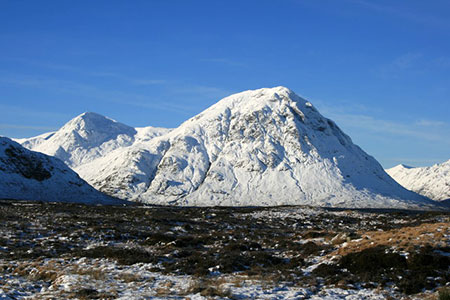
Click image to see photo description.
This walk from the head of Glencoe includes the two Munros on Buachaille Etive Mor, Stob Dearg and Stob na Broige. This hill lies close to the A82 near the head of Glencoe and its pyramid-like aspect is seen by many each year. Hidden from view, the hill's four-kilometre ridge contains two Munros plus two subsidiary summits. The route follows good paths and despite the steep approach to the ridge the walk offers no further difficulties.
The start is Altnafeadh (Grid ref. NN221563) where parking is available in parking areas on both sides of the A82. After parking head south along the track that leads across a bridge over the River Coupall towards the white cottage of Lagangarbh. Two hundred metres beyond the cottage the path forks. Keep right here and start to climb steadily soon crossing the Allt Coire na Tulaich. The path stays on the west side of the stream as the gradient steepens with the crags of Stob Dearg to your left.
Continuing upwards into dramatic Coire na Tulaich the path steepens with the coire wall ahead. However, you are faced with no technical difficulties with the ascent easing to reach a col (Grid ref. NN 216542). Turn left and follow the well-trodden path to the summit of Stob Dearg (1022 m.), the first Munro of the route. Take time to enjoy the view taking particular note of the onward route along the ridge to Stob na Doire and beyond to Stob na Broige.
Retrace your steps down to the col (NN216542) and continue ahead on an undulating path that follows the ridge before climbing steadily onto Stob na Doire's summit (1011 m.). Despite its height, Stob na Doire is not a Munro. A steepish descent leads down to the head of Coire Altruim (grid ref. NN201529) from where you will later descend to complete the route.
Continue ahead to cross Stob Coire Altruim with a short descent before the steady ascent along a narrowing ridge to reach Stob na Broige (956 m.). Enjoy the view which extends south-west to Loch Etive. To continue retrace your steps to the col at the head of Coire Altruim and turn left down the steep path which descends on the west side of Allt Coire Altruim to join the Lairig Gartain path (grid ref. NN199542). Follow this path down the valley to reach the A82. Turn right and return to the start.
Maps 

| Ordnance Survey Explorer 384 | Sheet Map | 1:25k | BUY |
| Anquet OS Explorer 384 | Digital Map | 1:25k | BUY |
| Ordnance Survey Digital Map Subscription | |||
| Latest Ordnance Survey Discounts | |||
Other walks nearby
| Walk 2819 | Stob na Broige, Buchaille Etive Mor, Glen Coe | mod/hard | 6.1 miles |
| Walk 2808 | Buachaille Etive Beag, Glen Coe | hard | 9.0 miles |
| Walk 2554 | The Lost Valley, Glen Coe | easy/mod | 4.2 miles |
| Walk 3251 | Bidean nam Bian via Stob Coire nan Lochan, Glencoe | hard | 5.0 miles |
| Walk 1496 | WHW - Day 6 - Kinlocheven to Fort William | moderate | 15.0 miles |
| Walk 3106 | Binnein Mor from Kinlochleven | hard | 10.2 miles |
| Walk 1039 | Am Bodach and Stob Coire a' Chairn | mod/hard | 9.5 miles |
| Walk 1094 | Blackwater Reservoir | moderate | 11.5 miles |
| Walk 2955 | Ridges & peaks of Bidean Nam Bian | very hard | 10.5 miles |
| Walk 3118 | Sgor na h'Ulaidh from Achnachon, Glen Coe | mod/hard | 8.0 miles |
Recommended Books & eBooks
Walking in Torridon
 This guidebook contains 52 day walks in Torridon, a remote and much-loved area of the Scottish Highlands. Based around Shieldaig and Slioch, the routes are split into 3 sections: easy walks, long and high level walks and mountain ascents over 2000ft including 9 Munros, and 5 outline suggestions for major ridge walks.
More information
Great Mountain Days in Scotland
 Inspirational guidebook to 50 challenging routes for mountaineers, scramblers, hillwalkers and fell runners, many long enough to backpack over 2 days, especially in winter (12 to 25 miles). A mix of classic routes and unsung gems across Scotland from Galloway to the Outer Hebrides in widely differing wild landscapes. With customised OS mapping.
More information
