Walk 1095 - printer friendly version
The Marton-cum-Grafton Eight Walk
Author - The Punchbowl at Marton
Length - 3.3 miles / 5.3 km
Ascent - 150 feet / 45 metres
Grade - easy
Start - OS grid reference SE416633
Lat 54.063971 + Long -1.3658978
Postcode YO51 9QW (approx. location only)
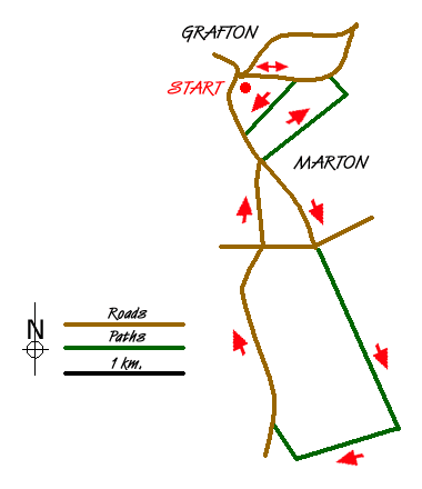
Before or after your walk you may wish to stand on the Millennium Sundial on the village green. Where your shadow falls tells you the time. Facing the interpretation panel turn left to go uphill on Thorny Hill Lane. When you near the brow of the hill, look for a fingerpost on your right where the woodland starts. The footpath brings you to Grafton Hills which are, along with nearby Wood Hills, the highest point for 20 miles around. The flock of handsome Soay sheep may be about. Pause for a look back across the lovely Vale of York and the lower Ure Valley.
As the route continues, you'll enter Marton, passing the 16th century Ye Olde Punch Bowl Inn. As you walk down Reas Lane you'll see the school, built in 1861, before you follow a track down to cross Goker Beck which flows down into the River Ure. Going uphill from the beck you'll climb through a type of stile known as a 'squeeze' stile. Look out across the fields for birds such as skylark, yellowhammer, pheasant, partridge, redwing and fieldfare, depending on the time of year. If you're really lucky you might spot a corn bunting.
The route continues past farm buildings and then behind Marton Wood before bringing you onto Legram Lane. Look for the cemetery on your left which was once the site of Marton's church. It is now also a nature reserve. The church was demolished in 1873 on the orders of the Reverend John Lunn, and you'll see the replacement he built further on as you cross over into Church Lane. Christ Church was built in 1875 using much of the carved stone from the previous building. It houses the second oldest church bell in the country on the side of the church. Inside, the font dates from 1320, and is well worth seeing.
Continue into the village past the shop and village hall and head down the right hand side of the pub car park. You'll find yourself reaching a high point on a path by the Sports Ground which gives you spectacular views across to the White Horse of Kilburn, as well as York Minster. With ups and downs, the result of this ground having been used to quarry gravel, you'll pass a white Trig Point. Standing at 75 metres above sea level, this is one of thousands of high-point markers used by the map makers of the Ordnance Survey. This was once the site of an Iron Age Hill Fort and you, like those ancient ancestors, can enjoy excellent views. Finally, take the pathway down to Thorny Hill Lane. The shops, pub and businesses which used to be here are long gone, but their names can still be seen on some of the houses as you turn left and downhill to the start.
Messaging & Social Media
Message Walking Britain and follow the latest news.

Mountain Weather
Stay safe on the mountains with detailed weather forecasts - for iOS devices or for Android devices.