Combe Gill Circuit from Seatoller
Lake District Walk
Nat Park - Lake District - Lake District Southern Fells
Wainwrights - Rosthwaite Fell
County/Area - Cumbria
Author - Lou Johnson
Length - 5.5 miles / 8.9 km Ascent - 2200 feet / 667 metres
Time - 5 hours 0 minutes Grade - moderate
Walk Route Description
Click image to visit gallery of 5 images.
On paper this appears to be an easy Lake District walk amidst some of the lesser heights of Lakeland. However it requires excellent navigational skills in bad weather and involves a steep ascent on grass in the early stages of the walk. You have been warned! Either park in the main car park at Seatoller or on the wide grassy verge (grid ref NY250136) on the lane to Thorneythwaite just opposite the cottages at Mountain View.
Wherever you park, head east along the main Borrowdale road towards Rosthwaite. Just after passing Mountain view cottages take the signed footpath that leads south east towards the slopes of Bessyboot. This path is waymarked and after crossing Combe Gill the path climbs steeply to join another path traversing the fellside. turn right (south) on this to follow Combe Gill upstream. As you head up the valley, the path gets nearer to the stream until you reach a ruined sheepfold. The hard work starts here!
Rottenstone Gill has carved a miniature ravine out of the hillside and you need to stay on the northern side of the gill heading on an intermittent path up the grassy fellside. The climb is easy underfoot although there are times when you wonder when its going to end. As you climb higher a clearly defined col between Bessyboot and Rosthwaite Cam becomes evident and this is your target. Eventually the grade eases and you reach the col where the delightfully situated Tarn at Leaves comes into view.
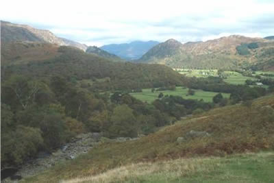
A short diversion to the summit of Bessyboot is recommended as it provides an excellent viewpoint for Borrowdale with Skiddaw towering over Derwentwater providing a wonderful background. After enjoying the view and return to the col. There is a path heading south although this splits a number of times and route finding can be difficult especially in bad weather. The next objective is the cairn on Rosthwaite Cam from where there is a good view of almost the whole route. At first the onward path heads south with the great bowl of the Combe to your right.
The topography is confusing with many hollows surrounded by crags. The path slowly turns west to reach Combe Door from where a steep ascent takes you to the airy summit of Combe Head. Once again the view is superb with Glaramara dominant to the south. Descending west from Combe Head you soon reach the main Glaramara path and turning north on this you descend into Borrowdale. Well marked you should find no difficulty finding your way back to the cottages at Mountain View.
One final warning - this walk is hard to follow on the 1:25000 map so the 1:50000 should not be used if there is any possibility of poor visibility. Care should also be taken to avoid unmarked descents into the Combe as there are some steep and dangerous crags especially in the vicinity of Dovenest Crag.
Maps 

| Ordnance Survey Explorer OL4 | Sheet Map | 1:25k | BUY |
| Anquet OS Explorer OL4 | Digital Map | 1:25k | BUY |
| Ordnance Survey Digital Map Subscription | |||
| Latest Ordnance Survey Discounts | |||
Other walks nearby
| Walk 1245 | Castle Crag & Grange | easy/mod | 6.0 miles |
| Walk 3328 | Eagle Crag & Seargeant's Crag from Stonethwaite | moderate | 7.0 miles |
| Walk 3133 | Ullscarf and Watendlath from Stonethwaite | mod/hard | 10.0 miles |
| Walk 1693 | Grange & Watendlath | easy/mod | 7.6 miles |
| Walk 1444 | Great Gable (Borrowdale route) | hard | 12.0 miles |
| Walk 1114 | Scafell Pike via Corridor Route | hard | 9.5 miles |
| Walk 1236 | Styhead Tarn and Seathwaite Fell | moderate | 7.0 miles |
| Walk 1306 | Base Brown & Great Gable | mod/hard | 6.0 miles |
| Walk 2046 | Great End via the north west face from Seathwaite | very hard | 7.0 miles |
| Walk 1826 | Green Gable & Gillercomb Horseshoe | moderate | 5.5 miles |
Recommended Books & eBooks
Hadrian's Wall Path
 Hadrians Wall Path guidebook to walk the 84 mile National Trail. Described in both directions, the main description is west to east between Bowness-on-Solway and Wallsend, Newcastle, with extensions to Maryport and South Shields. With extensive historical information related to this World Heritage site and separate 1:25,000 OS map booklet included.
More information
Outdoor Adventures with Children - Lake District
 Guidebook to 40 outdoor adventures in the Lake District with children under 12, including walking, cycling, orienteering, paddling, boating, hostelling and more. Graded activities for varying age ranges or for families with children of different ages.
More information
