Roaches and Lud's Church
Peak District Walk
Nat Park - Peak District - The Roaches
County/Area - Staffordshire
Author - Lou Johnson
Length - 7.3 miles / 11.8 km Ascent - 1340 feet / 406 metres
Time - 5 hours 0 minutes Grade - moderate
Walk Route Description
Click image to visit gallery of 6 images.
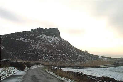
For many travellers on the A53 driving north from Leek to Buxton, the distinct and rocky escarpment known as the Roaches comes as a surprise. Offering some of the best walking territory in Staffordshire, the moorlands in the northern part of this county fall within the boundaries of the Peak District National Park. This walk is ideal for short winter days when the area is relatively quiet. It provides an interesting excursion letting you sample one of Staffordshire's scenic highlights.
From Easter to late September this area is popular with visitors and access/parking restrictions are strictly enforced. In winter it is much different and usually no problems are encountered parking on the lane that runs parallel to the escarpment. On this occasion we parked on the road near Hen Cloud (grid ref SK004620) and headed north along the lane to take the first major path on the right, which leads over a col to Well farm. Immediately after leaving the lane you will see a small stone built house ahead, "Rockhall" (now used as a climbing hut). Leaving the main path over the col, walk in front and then to the left hand side of the house. Take the path that climbs up through the crags to gain the ridge.
Once the ridge has been reached follow it north with improving views as you gain height. On the way to the summit of the Roaches you will pass Doxey Pool, which apparently is the haunt of some strange creatures! Equally weird are the reports of Wallabies seen in this area - animals that escaped from a local zoo many years ago. The walking is easy and good speed can be maintained especially on the downhill section to Roach End.
Turn off right from the main ridge path here (ignoring the road heading south east) and go north crossing the first stile in the wall on your left. This leads to a path that descends north towards Gradbach Wood. On entering the wood the path splits and it is recommended you follow the branch that keeps to the edge of the trees. This path contours across the hillside and leads you without problem to Lud's Church, which was used by the proto-protestant Lollards - led in this case by Wlater de Ludwark who was arrested holding an illegal service and whose granddaughter Alice died in the siege - her statue and ghost later to haunt the place.
Shortly after leaving Lud's Church you meet the main path coming up from Gradbach and this needs to be followed westwards in the direction of Danebridge. The going remains easy and you soon find yourself at the western end of the Roaches escarpment with a wide ranging view across the Cheshire Plain. Turning left you climb again to pass above High Forest farm before dropping down to Roach End. From here it is an easy stroll down the tarmac lane back to where you parked. Alternatively you can follow your outward route over the summit of the Roaches, which adds another 100 metres of ascent to the route.
Maps 

| Ordnance Survey Explorer OL24 | Sheet Map | 1:25k | BUY |
| Anquet OS Explorer OL24 | Digital Map | 1:25k | BUY |
| Ordnance Survey Digital Map Subscription | |||
| Latest Ordnance Survey Discounts | |||
Other walks nearby
| Walk 1707 | The Roaches short circular | easy/mod | 5.0 miles |
| Walk 3030 | Roaches & Lud's Church | easy/mod | 7.0 miles |
| Walk 1288 | Roaches & Hen Cloud from Tittesworth Reservoir | moderate | 8.5 miles |
| Walk 2577 | Hawk's Nest, Goldstitch Moss & Lud's Church | moderate | 8.0 miles |
| Walk 1596 | Lud's Church and Roach End from Gradbach | easy/mod | 4.5 miles |
| Walk 1598 | Lud's Church, Back Forest & Clough Head | easy/mod | 6.8 miles |
| Walk 3323 | Gradbach, Three Shires Head & Knotbury | easy/mod | 7.1 miles |
| Walk 3197 | Flash, Knotbury & Three Shires Head | easy/mod | 8.2 miles |
| Walk 2519 | The Cloud from Rushton Spencer | easy/mod | 9.0 miles |
| Walk 2604 | Dane Valley & Wincle from Rushton Spencer | moderate | 9.5 miles |
Recommended Books & eBooks
Walking in the Peak District - White Peak East
 Guidebook describing 42 half-day and day walks in the limestone landscapes of Derbyshire's White Peak, part of the Peak District National Park. One of two volumes, this book covers the east of the region, with potential bases including Bakewell, Eyam, Castleton, Birchover, Matlock and Wirksworth.
More information
Dark Peak Walks
 Guidebook to 40 walks in the Dark Peak area of the Peak District National Park. 35 circular routes for most abilities, from 8km to 19km, around Edale, Marsden, Fairholmes, Baslow and Castleton, including Kinder Scout and Mam Tor, and 5 longer (25km to 45km) routes highlighting the best of the Gritstone Edges, High Moorland and Deep Valleys.
More information
