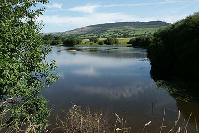
Roaches & Hen Cloud from Tittesworth Reservoir
Peak District Walk
Nat Park - Peak District - The Roaches
County/Area - Staffordshire
Author - Lou Johnson
Length - 8.5 miles / 13.8 km Ascent - 1400 feet / 424 metres
Time - 5 hours 40 minutes Grade - moderate
Walk Route Description
Click image to visit gallery of 12 images.
The Roaches are a familiar landmark for anyone driving from Leek to Buxton. The Roaches are a gritstone escarpment providing excellent walking and climbing. A small outlier, Hen Cloud, has also been included in this route. The start is Tittesworth Reservoir, well known for its varied birdlife and the route also includes some of Staffordshire's more attractive countryside.
The start of this Peak District walk is the Tittesworth Reservoir car park (Grid ref. SJ993602) where a charge is levied. Roadside parking is also available nearby. From the car park retrace your steps to the road and turn left into the hamlet of Meerbrook. Turn right at the road junction and continue along the road for a short way. Take the first footpath on your right and follow this through to Greenlane. Here you join the road for a short way before following another footpath on your right that leads across fields to Roach Side Farm and the road (Grid ref. SJ 993630). Turn right along the lane, which sees very little traffic, as far as Roach End (Grid ref. SJ 995645).
Turn right along the flagged path that leads south along the Roaches escarpment. The views are good and usually you will see climbers on the crags. After passing Doxey Pool drop down to the front edge of the escarpment at Rockhall. From here skirt the end of the crags and follow the footpath through a field and begin the ascent of Hen Cloud.
The Descent from Hen Cloud is confusing. However from the summit area head northeast and descend into the wood. Here you will join a clear path that should be followed south. This path exits the woods and becomes a track. Follow this to the lane. Turn left and follow the lane towards Upper Hulme. After passing some cottages on the left locate a wide driveway into a farm on your right (Grid ref. SK 010608). The unsigned right of way passes to the right of the buildings and then becomes clearly marked. This path leads across fields to reach a road (Grid ref SJ 999604). Turn right and the start is a few minutes along this road.
Maps 

| Ordnance Survey Explorer OL24 | Sheet Map | 1:25k | BUY |
| Anquet OS Explorer OL24 | Digital Map | 1:25k | BUY |
| Ordnance Survey Digital Map Subscription | |||
| Latest Ordnance Survey Discounts | |||
Other walks nearby
| Walk 1707 | The Roaches short circular | easy/mod | 5.0 miles |
| Walk 3030 | Roaches & Lud's Church | easy/mod | 7.0 miles |
| Walk 1178 | Roaches and Lud's Church | moderate | 7.3 miles |
| Walk 2577 | Hawk's Nest, Goldstitch Moss & Lud's Church | moderate | 8.0 miles |
| Walk 1596 | Lud's Church and Roach End from Gradbach | easy/mod | 4.5 miles |
| Walk 1598 | Lud's Church, Back Forest & Clough Head | easy/mod | 6.8 miles |
| Walk 3323 | Gradbach, Three Shires Head & Knotbury | easy/mod | 7.1 miles |
| Walk 3197 | Flash, Knotbury & Three Shires Head | easy/mod | 8.2 miles |
| Walk 2519 | The Cloud from Rushton Spencer | easy/mod | 9.0 miles |
| Walk 2604 | Dane Valley & Wincle from Rushton Spencer | moderate | 9.5 miles |
Recommended Books & eBooks
Walking in the Peak District - White Peak East
 Guidebook describing 42 half-day and day walks in the limestone landscapes of Derbyshire's White Peak, part of the Peak District National Park. One of two volumes, this book covers the east of the region, with potential bases including Bakewell, Eyam, Castleton, Birchover, Matlock and Wirksworth.
More information
Dark Peak Walks
 Guidebook to 40 walks in the Dark Peak area of the Peak District National Park. 35 circular routes for most abilities, from 8km to 19km, around Edale, Marsden, Fairholmes, Baslow and Castleton, including Kinder Scout and Mam Tor, and 5 longer (25km to 45km) routes highlighting the best of the Gritstone Edges, High Moorland and Deep Valleys.
More information
