Kinder Downfall from Hayfield
Peak District Walk
Nat Park - Peak District - Kinder Scout Edale
County/Area - Derbyshire
Author - Lou Johnson
Length - 8.0 miles / 13 km Ascent - 1400 feet / 424 metres
Time - 5 hours 20 minutes Grade - moderate
Walk Route Description
Click image to visit gallery of 6 images.
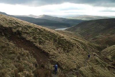
This walk to Kinder Downfall starts from the quarry on the road from Hayfield to the Kinder Reservoir (grid ref SK047868). This quarry was a very significant place in the annals of hill walking as it was here that the mass trespass onto Kinder Scout started on 24th April 1932. Details of this momentous event is remembered on a brass plaque affixed to the quarry face. Leaving the car park head northeast up the lane to reach the main gates of the Kinder Reservoir. Then take the footpath that climbs along the northern side of the reservoir with a good view of Kinder Downfall across the water.
Soon you reach William Clough, which starts at the end of the reservoir. Keep to the path that follows the stream in this narrowing valley. After a steady climb you reach the paved "Pennine Way" at Ashop Head. Turning right (southeast) climb the plateau edge. The climb is steep but on a pitched path and by the time you reach the plateau the uphill work for the day is complete.
Keep to the main path that follows the plateau edge - the walking is easy, and the rocky defile of Kinder Downfall is reached quickly. Don't be disappointed if there is little water cascading off the plateau as it is only on rare occasions when there is a dramatic amount of water present. On windy days much of the water is blown away and you might find yourself subject to an unscripted drenching. With plenty of shelter behind rocks, it is a good place to linger even on a cold and windy day.
Turn south to follow the edge keeping to the main path, which avoids most of the bad peat groughs. The trig point of Kinder Low is reached and from here it is better to continue past Edale Rocks to reach the col (spot height 533) where the Pennine Way comes up from Edale. Turn right (west) to pass the ancient Edale Cross and head down Oaken Clough.
There are many possible routes back to the quarry, but it is best to leave the rather stony track just beyond Stony Ford to take the path that contours across the hillside. Continue past the foot of Kinderlow End and then turn west to Tunstead Clough Farm. From here it is only a short stroll back to the quarry.
Maps 

| Ordnance Survey Explorer OL1 | Sheet Map | 1:25k | BUY |
| Anquet OS Explorer OL1 | Digital Map | 1:25k | BUY |
| Ordnance Survey Digital Map Subscription | |||
| Latest Ordnance Survey Discounts | |||
Other walks nearby
| Walk 2507 | South Head & Edale Cross from Hayfield | moderate | 8.0 miles |
| Walk 1486 | Harry Hut, Mill Hill & Doctor's Gate from Glossop | moderate | 11.3 miles |
| Walk 3407 | Chinley to Edale without a car | moderate | 9.3 miles |
| Walk 2546 | Lantern Pike & Cown Edge from Rowarth | easy/mod | 8.0 miles |
| Walk 2534 | Chinley Churn & South Head | easy/mod | 7.5 miles |
| Walk 1923 | Cown Edge & Whiteley Nab from Chunal | easy/mod | 6.5 miles |
| Walk 2622 | Sett Valley & Kinder from New Mills | moderate | 10.0 miles |
| Walk 2523 | Black Rocks & Bollinhurst Reservoir | easy | 5.0 miles |
| Walk 2567 | Lyme Park & Dissop Head | easy | 6.0 miles |
| Walk 1116 | Grains in the Water & Alport Castles | mod/hard | 12.0 miles |
Recommended Books & eBooks
Walking in the Peak District - White Peak East
 Guidebook describing 42 half-day and day walks in the limestone landscapes of Derbyshire's White Peak, part of the Peak District National Park. One of two volumes, this book covers the east of the region, with potential bases including Bakewell, Eyam, Castleton, Birchover, Matlock and Wirksworth.
More information
The Pennine Way
 Guidebook to the Pennine Way National Trail with OS map booklet. The 265 mile route from Edale to Kirk Yetholm takes three weeks to walk and is suitable for fit and experienced long distance walkers. The route crosses the Peak District, Yorkshire Dales and North Pennines National Parks. Includes separate OS 1:25,000 map booklet of the route.
More information
