Walk 1220 - printer friendly version
Dunkery Beacon Walk
Author - Lou Johnson
Length - 8.0 miles / 13 km
Ascent - 1170 feet / 355 metres
Grade - moderate
Start - OS grid reference SS923387
Lat 51.137409 + Long -3.5407774
Postcode TA24 7DU (approx. location only)
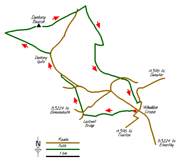
Exmoor has much to offer walkers and this route includes the all of the main elements that typify the National Park. It begins with a stroll across cultivated farmland to reach the open moor and concludes with a walk through a mature wooded combe or deep valley.
The start is the small carpark in Wheddon Cross (grid ref. SS923387). This village is the highest in Exmoor and provides an excellent base from which to explore the National Park. From the carpark proceed across the cricket ground and take the gate immediately to the right of the pavilion. Keeping the boundary fence or hedge to your right continue on this waymarked route to reach a footbridge (grid ref. 915386). Cross this and follow the stream keeping it on your right to reach the village of Luckwell Bridge.
Reach the main road and locate Long Lane which heads north. This sunken track is enclosed between high hedges as it climbs to Trottsway Cross. Go straight over and continue climbing along a track to reach Long Lane Head. Turn left along the road to be rewarded with good views especially to your right. Reaching Dunkery Gate, ignore the path that heads straight to the summit of the Beacon instead following the track heading towards Great Rowbarrow.
At the junction of paths (grid ref. 880414) turn sharp right and follow the clear path to the summit of Dunkery Beacon. It is a busy place due to the proximity if suitable parking but does provide excellent views in all directions especially north towards the coast. Leave the summit on a broad path heading northeast. Reaching the road (grid ref. 904420) go straight over continuing in the same direction. At the first path junction turn sharp right and head southwards across open moor. After about a mile you will reach an area criss-crossed by tracks and paths (grid ref. 913412).
At the boundary wall turn right and keep this on your left descending into the combe to reach a gate with a fingerpost (grid ref. 910406) on your left. Go through this and continue to descend. Reaching a broader track go straight across to reach a stream. Cross this and follow its southern bank downstream (south). You are now in beautiful mature woodland. Continuing to follow the stream you reach a lane (Drapers Way). Cross this and follow the bridleway as it climbs through woods to reach open fields. At the top of the climb turn left to reach the main road. Turn right along this and within a few minutes you are back in the centre of Wheddon Cross.
Messaging & Social Media
Message Walking Britain and follow the latest news.

Mountain Weather
Stay safe on the mountains with detailed weather forecasts - for iOS devices or for Android devices.