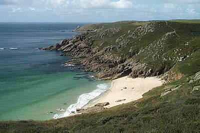
Land's End & Sennen Cove from Porthcurno
Cornwall AONB Walk
Region - Cornwall AONB
County/Area - Cornwall
Author - Lou Johnson
Length - 6.5 miles / 10.6 km Ascent - 1355 feet / 411 metres
Time - 4 hours 40 minutes Grade - moderate
Walk Route Description
Click image to visit gallery of 9 images.
This walk includes a visit to Land's End and the spectacular Gwennap Head with its amazing rock architecture. As with many of the coastal walks featured on the "Walking Britain" website, it has been designed to make the best of local public transport so you can concentrate on the delights of coastal walking on the South West Coast Path. As with any coastal walking, do not underestimate the time taken as there are many ups and downs and the path is never straight!
It is suggested you park at Sennen Cove and catch a bus to Porthcurno. This service is relatively frequent but is quite complex and it is important that you make sure the bus you catching goes to Porthcurno on its way to Penzance. Assuming you have got your homework right, alight at the main bus stop in the centre of Porthcurno village (grid ref. SW383225)and head through the main car park down to the beach.
The onward route could easily be described as "follow the South West Coast Path back to Sennen Cove" but the route is worthy of a more detailed description. The SWC Path climbs steeply up the cliffs on leaving Porthcurno beach and skirts round the inland side of the world famous Minack Theatre, which you sadly don't get to see, to enter the theatre's car park. Cross this and exit at the western end to regain the coastal footpath, which stays at cliff top level before dropping down to go across the back of Porth Chapel beach.
The next section through to Porthgwarra is pleasant and you make good progress to reach this hamlet with a small, sandy beach. The temptation on the next section is to take the short cut across the back of Gwennap Head to Porth Loe but to do so would mean that you have missed one of the highlights of the Cornish Coast. Instead stay on the path nearest to the sea, passing the Landmarks on your right, and enjoy the rocky cliffs, which act as a magnet for rock climbers. Rock stacks and an arch add an extra dimension to this spectacular section of coast. In wet weather care is needed on some sections as a slip could be fatal.
Continue on the main footpath always staying as near as you can to the sea. Most of the minor headlands are worth visiting even though a short diversion from the path is necessary. Leaving Gwennap Head Land's End seems a short walk away but remember coastal walking always take longer. Continuing west, Nanjizal is the next highlight being a beautiful bay edged with rocky cliffs and shortly after the buildings on Land's End start to become more obvious.
Despite the large numbers of visitors to this most westerly point of the English mainland, few venture very far from their transport and you can walk undisturbed to within a half of a mile of the theme park. Notices abound warning visitors of the dangers of getting too close to the cliffs. Passing Dr Syntax's Head (the true most westerly point) the number of people suddenly decreases and you are back to typical Cornish coastal walking for the remaining stretch to Sennen Cove.
Maps 

| Ordnance Survey Explorer 102 | Sheet Map | 1:25k | BUY |
| Anquet OS Explorer 102 | Digital Map | 1:25k | BUY |
| Ordnance Survey Digital Map Subscription | |||
| Latest Ordnance Survey Discounts | |||
Other walks nearby
| Walk 2298 | Porthgwarra & St Levan Circular | easy | 4.8 miles |
| Walk 2614 | St Loy's Cove & Logan Rock | moderate | 8.5 miles |
| Walk 2354 | Merry Maidens & Lamorna Cove | easy | 4.1 miles |
| Walk 1225 | Sennen Cove & Botallack from St Just | moderate | 7.5 miles |
| Walk 2616 | The moors and hills of Penwith | moderate | 14.0 miles |
| Walk 2205 | Newlyn - a village trail | easy | 1.0 miles |
| Walk 1028 | Chun Quoit and Botallack | moderate | 8.0 miles |
| Walk 3325 | Chun Quoit & Carn Kenidjack | easy | 4.0 miles |
| Walk 2207 | Penzance - a town stroll | easy | 1.5 miles |
| Walk 3501 | Penzance to Porthcurno via Mousehole and Lamorna | moderate | 11.0 miles |
Recommended Books & eBooks
The South West Coast Path
 Guidebook to walking the entire South West Coast Path National Trail. The route runs for 630 miles from Minehead to Poole along the north Devon, Cornish, south Devon and Dorset coastline. Divided into 45 stages, this long-distance coastal trek could be completed within 4 weeks, or walked in sections. Guide includes maps and essential information.
More information
Walking in Cornwall
 This guidebook includes routes to 40 day walks in Cornwall. From short, easy strolls to longer, wilder routes, there is plenty to appeal to both families and experienced walkers. The walks explore the interior and coasts, including walks through picturesque villages, old tin-mining areas and the Lizard and Land's End Peninsulas.
More information
