Carnedd Llewelyn, Llyn Eigiau & Llyn Cowlyd
Snowdonia/Eryri Walk
Nat Park - Snowdonia - Western Carneddau
County/Area - Conwy
Author - Don Williams
Length - 16.0 miles / 26 km Ascent - 4100 feet / 1242 metres
Time - 12 hours 10 minutes Grade - hard
Walk Route Description
Click image to visit gallery of 13 images.
This Snowdonia (Eryri) walk crosses some of the most remote land in Wales and offers some wonderful walking in a wild landscape. The start is Gwern Gof Isaf (Grid Ref. SH685603). There is a small charge ( £ 1 in 2007) which is payable at the farm.
From the car park turn right and go along the A5 road for a short distance then cross and enter the surfaced service road to the Ffynnon Llugwy Reservoir via the stile. Continue along this road for 2.2 km until it takes a sharp left turn. At this point continue straight ahead on a path which will lead you above the edge of Ffynnon Llugwy (Pic.1.) to the zig-zag path up to Bwlch Eryl Farchog. (Pic.2.) This path is rather loose but not difficult. (Pic.3 Pic.4) Once on the col, turn left and follow the path over Penywaenwen and continue up to Carnedd Llewelyn. The path is clear and generally easy to follow with one short section where hands are required.
From the summit of Carnedd Llewelyn turn north along the Carneddau ridge.(Pic.5.) The route crosses an area of small boulders and at times the path can be very indistinct. Keep on along this path to Foel Grach. On the north side of the summit amongst a pile of rocks is the Mountain Refuge Shelter. (Pic.6.)
Leave Foel Grach and continue North to Garnedd Uchaf. From here head towards Foel fras on a bearing of about 50 deg. Until a VERY indistinct path is crossed at SH6901/6720. Turn right on this path on a bearing of 73 deg and continue down the grass/heather slope until you come to a wall/fence. (Pic.7) Cross over the stile and continue down on this bearing to a point at SH7030/6765. From here take a bearing of 106 deg and continue down this grass/heather/reed slope to an iron stile. Over the stile and the footpath is quite easy to see. After about 0.2 km the path forks. Take the right-hand path until you reach a small dam. (Pic.8) Cross the river over the dam, bear left (path not very clear at this point) and then the path becomes a grassy/stony track.
Keep right at a junction (0.3 km) and after 1 km turn left at a junction and follow the stone surfaced track to a car-park. Turn right through the car park and over the stile, following the stone surfaced road into Cwm Eigiau, (Pic.9) passing the break in the dam wall and crossing the river via the bridge. (Pic.10.) Over the bridge go left. Continue along the stony track, pass a round tower on your right (ventilator for pipeline), walk across a causeway over a small ravine. Pass through a gate and climb over the stile immediately on your right.
Follow the path up and round to the left to join a grassy track, pass a derelict cottage (Eilio), cross the stream and go over the stile. Continue up the grassy path with the fence on your right until you come to another stile over a wall. After crossing this stile keep ahead on the path to the top of the small hill. Over the top take the right hand fork where the path divides, keep to the right of a small knoll after a wet section and continue with the wall on your right. When the wall turns left, go through a gap near the corner. Cross a fence by a bar stile. Then cross a stream by a stone sheep enclosure and keep on to a stony track. Shortly after another track joins from the left, take an indistinct grass path off to the left. Pass some ruins on your right, cross a couple of small streams and gradually head down towards the lake (Llyn Cowlyd) until you join the path alongside the lake.
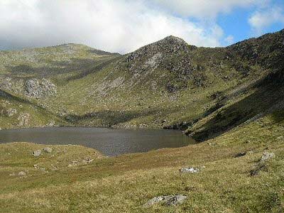
Turn right along the lake. The path follows the lake until rising up at the head of the lake (Pic.12) and leaves the valley. The path comes to a stile by a footbridge. Do not cross the stile but turn right and follow the line of the leat (artificial water channel) until you cross this on a small footbridge. Follow the leat as it winds round below Pen Llithrig yr Wrach and Pen yr Helgi Ddu until you arrive at the surfaced road. (Pic.13). Turn left back to the A5 road then turn right back to car park.
Maps 

| Ordnance Survey Explorer OL17 | Sheet Map | 1:25k | BUY |
| Anquet OS Explorer OL17 | Digital Map | 1:25k | BUY |
| Ordnance Survey Digital Map Subscription | |||
| Latest Ordnance Survey Discounts | |||
Other walks nearby
| Walk 3056 | Pen yr Helgi Du from Ogwen Valley | moderate | 5.5 miles |
| Walk 1150 | The High Carneddau | hard | 10.0 miles |
| Walk 1215 | Tryfan & Llyn Ogwen from Ogwen Valley | mod/hard | 5.5 miles |
| Walk 3001 | Tryfan North Ridge from Ogwen Valley | hard | 3.5 miles |
| Walk 3026 | Tryfan & the Eastern Tops from Ogwen Valley | hard | 5.8 miles |
| Walk 2820 | Carneddau traverse from Llyn Ogwen | mod/hard | 14.0 miles |
| Walk 2650 | Tryfan, the Glyders & Y Garn | very hard | 8.0 miles |
| Walk 1088 | Glyder Ridge traverse | hard | 5.5 miles |
| Walk 1186 | Y Garn | mod/hard | 4.5 miles |
| Walk 3019 | Y Garn & Carnedd y Filiast Ogwen Cottage | hard | 8.5 miles |
Recommended Books & eBooks
Mountain Walking in Snowdonia
 Guidebook to 40 of Snowdonia's best day walks, with routes up Snowdon and Tryfan, including the Snowdon Horseshoe, Cadair Idris, Y Garn and The Rhinogs. The routes range from Grade 1 scrambles like Crib Goch or Bristly Ridge, to riverside and forest walks. Includes details of a 2-day traverse of all 15 of Snowdonia's 3000ft peaks.
More information
The Cambrian Way
 Guidebook to the Cambrian Way, a challenging three-week mountain trek through Wales from Cardiff to Conwy. The 470km un-waymarked route is presented from south to north. Often sticking to long, beautiful ridgelines, it crosses wild and rugged terrain and visits many of Wales's highest mountains, including Snowdon.
More information
