Shining Tor & Windgather Rocks from Lamaload
Peak District Walk
Nat Park - Peak District - Goyt Valley Lyme Park
County/Area - Cheshire & Derbyshire
Author - Lou Johnson
Length - 7.5 miles / 12.2 km Ascent - 1355 feet / 411 metres
Time - 5 hours 10 minutes Grade - moderate
Walk Route Description
Click image to visit gallery of 6 images.
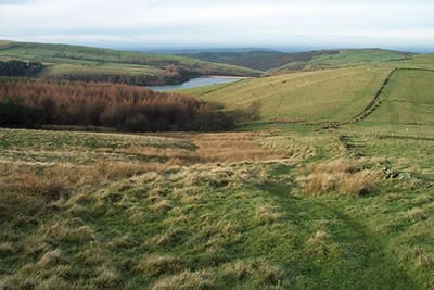
This Peak District walk on the western moors starts with a climb to the highest point in Cheshire and continues with a good ridge walk. It concludes with a section along the lanes with the opportunity to visit one of the more interesting churches in the area. The start is the small car park at Lamaload Reservoir (grid ref SJ975753). This can be reached down a lane from the A537 Buxton to Macclesfield road about 2 miles west of the "Cat & Fiddle". Please note that the car park at Lamaload reservoir, despite being an amenity provided by the National Park, is only available to the general public from 7th November to 30th April. At other times it is the exclusive preserve of an angling club, who keep the barrier locked. Some parking is available at the roadside.
Exit the car park and turn right along the lane in the direction of the A537. Where the lane bends right go through the gate on the left along a track signed to Shining Tor. This track/path climbs steadily and where it forks keep on the right-hand path, which climbs more steeply across rough pasture.
Stay with this path as it swings south to follow a wall on your right. The path descends gently and turns east before climbing again to reach the wall and the summit of Shining Tor. The view in all directions is good with many landmarks in evident. To the south you can see the Roaches and Shutlingsloe, whilst away to the northeast Mam Tor and Kinder Scout are in view. After taking in the view head north along the wall, which is to your left over the next lengthy section of ridge to Pym Chair. The ridge marks the boundary between Cheshire and Derbyshire and after a wet spell can be rather boggy so be prepared for a little bog trotting!
Reaching the road at Pym Chair, turn right for a short way before following the continuation of the ridge path northwards to Windgather Rocks. (Note - if you are short of time or energy then you may omit the next section and instead turn left along the road and follow the instructions further down the page). The path parallels the road and is often wet in which case it is better to walk on the road. Windgather Rocks offer a choice nursery routes and you will often see climbers enjoying the challenge. The grassy top also provides a pleasant place to stop for a break.
The route now retraces the route for some way and it is probably easier to use the road following it as far as a T-junction where you turn right. This lane descends to Jenkin Chapel with its interesting history and if you have time allow a few minutes here to investigate this rather utilitarian structure. Turn left at Jenkin Chapel and follow the lane back to the start.
Maps 

| Ordnance Survey Explorer OL24 | Sheet Map | 1:25k | BUY |
| Anquet OS Explorer OL24 | Digital Map | 1:25k | BUY |
| Ordnance Survey Digital Map Subscription | |||
| Latest Ordnance Survey Discounts | |||
Other walks nearby
| Walk 3588 | Rainow Circular | easy/mod | 5.5 miles |
| Walk 1092 | Taxal Edge, Jenkin Chapel & Pym Chair | moderate | 8.5 miles |
| Walk 2576 | Fernilee Reservoir, Goyt Valley | easy | 6.0 miles |
| Walk 3510 | Shining Tor, Cats Tor & Foxlow Edge | easy/mod | 7.0 miles |
| Walk 1183 | Shining Tor & Axe Edge Moor | moderate | 9.0 miles |
| Walk 2605 | White Nancy & Saddle of Kerridge Nr Bollington | easy | 4.5 miles |
| Walk 2506 | Tegg's Nose from Trentabank | moderate | 7.5 miles |
| Walk 2535 | Wildboarclough & Shutlingsloe from Trentabank | moderate | 7.0 miles |
| Walk 1461 | Shutlingsloe from Trentabank | easy/mod | 3.0 miles |
| Walk 1502 | Shutlingsloe and Macclesfield Forest from Trentabank | moderate | 9.0 miles |
Recommended Books & eBooks
Walking in the Peak District - White Peak East
 Guidebook describing 42 half-day and day walks in the limestone landscapes of Derbyshire's White Peak, part of the Peak District National Park. One of two volumes, this book covers the east of the region, with potential bases including Bakewell, Eyam, Castleton, Birchover, Matlock and Wirksworth.
More information
Dark Peak Walks
 Guidebook to 40 walks in the Dark Peak area of the Peak District National Park. 35 circular routes for most abilities, from 8km to 19km, around Edale, Marsden, Fairholmes, Baslow and Castleton, including Kinder Scout and Mam Tor, and 5 longer (25km to 45km) routes highlighting the best of the Gritstone Edges, High Moorland and Deep Valleys.
More information
