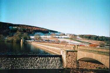
Fernilee Reservoir, Goyt Valley
Peak District Walk
Nat Park - Peak District - Goyt Valley Lyme Park
County/Area - Derbyshire
Author - Mike Bexley
Length - 6.0 miles / 9.8 km Ascent - 900 feet / 273 metres
Time - 3 hours 50 minutes Grade - easy
Walk Route Description
Click image to visit gallery of 3 images.
This relaxed short Peak District walk in Derbyshire is beautiful in any season but the woods viewed across the water in spring and autumn, are exceptional. I have also provided two options that reduce the distance. All the paths are well defined making direction finding very easy.
Start from the car park that overlooks Errwood Reservoir (Grid ref SK013756) opposite the Sailing Cub. Walk down the road towards the dam to take the footpath on the left heading north. Just after this footpath gate from the road, take the path ahead that eventually descends to Fernilee Reservoir built in 1938. This old path, part of the vast estate that occupied this area prior to the arrival of the reservoir, threads its way through the trees ending at a narrow lane (Grid ref. 011776). Turn right down the lane to the dam.
This is your first option to cut short your walk by crossing over the dam and turning right to pick up the returning walk.
Do not cross over the dam but turn left along the farm road, then just before the first farm - Knipe Farm (grid ref 011783), descend right down to a small gate in the wall. Then continue left to follow the wall to the back of the house. Descend right down the field to a five bar gate with a fat yellow arrow painted on it. This leads at first to a green lane down to the River Goyt then continues as a footpath alongside the river to a footbridge (Grid ref 011787).
Here is the second option, cross over the bridge, turn right and pick up the returning walk.
Continuing with the full walk, do not cross over the river but follow the path alongside the river then climbing up through the woods to exit onto fields. The clear path crosses the fields to the narrow Whiteleas Road (Grid ref 006795). Turn right along this road through the gate to the church (Grid ref 006798).
At the church wall turn right down the steep lane that passes through the cemetery to a river ford. To save getting your feet wet cross over the bridge on the left then climb up the path ahead to turn right through the gate to the footpath. The footpath follows the river, now on your right, passing the bridge (the second option joins here) to the very large concrete building housing the water treatment plant.
Keep the building on your right to follow the service road that climbs up to a lane, turn right towards the dam (the first option joins here). Then go left on the footpath that used to be the railway (Grid ref 015777). This level path ends near Errwood Dam completed in 1967. Proceed through the small gate on your right following the path that keeps to the foot of the dam then climbs up the steep hill to the gate to the road. Turn right back to your start.
Maps 

| Ordnance Survey Explorer OL24 | Sheet Map | 1:25k | BUY |
| Anquet OS Explorer OL24 | Digital Map | 1:25k | BUY |
| Ordnance Survey Digital Map Subscription | |||
| Latest Ordnance Survey Discounts | |||
Other walks nearby
| Walk 1092 | Taxal Edge, Jenkin Chapel & Pym Chair | moderate | 8.5 miles |
| Walk 1233 | Shining Tor & Windgather Rocks | moderate | 7.5 miles |
| Walk 2527 | Kettleshulme & Taxal Edge from Lamaload | moderate | 10.0 miles |
| Walk 1183 | Shining Tor & Axe Edge Moor | moderate | 9.0 miles |
| Walk 1728 | Axe Edge Moor & Three Shires Head | easy/mod | 7.2 miles |
| Walk 3136 | Shining Tor & Goyt's Clough | easy/mod | 5.1 miles |
| Walk 2635 | The edges of Combs Moss near Chapel-en-le-Frith | easy/mod | 7.5 miles |
| Walk 1652 | Three Shires Head | easy | 4.5 miles |
| Walk 2233 | Flash & Three Shires Head | easy/mod | 6.2 miles |
| Walk 2272 | Flash Circular from Cistern Clough | moderate | 8.0 miles |
Recommended Books & eBooks
Great Mountain Days in the Pennines
 An inspirational guidebook to 50 classic walks on the rolling Pennine landscape. The graded routes, between 6 and 13 miles in length, cover classic Pennine fells and moorland such as Whernside, Ilkley Moor and Pendle Hill; exploring the North and South Pennines, Yorkshire Dales, Howgills and Dark Peak. Many routes are also suited to fell running.
More information
Walking in the Peak District - White Peak East
 Guidebook describing 42 half-day and day walks in the limestone landscapes of Derbyshire's White Peak, part of the Peak District National Park. One of two volumes, this book covers the east of the region, with potential bases including Bakewell, Eyam, Castleton, Birchover, Matlock and Wirksworth.
More information
