Pap of Glencoe (Route B) from Glencoe Village
Highland Walk
County/Area - Highland - Fort William Lochaber
Author - Andy Smith
Length - 4.2 miles / 6.8 km Ascent - 2200 feet / 667 metres
Time - 4 hours 20 minutes Grade - moderate
Maps 

| Ordnance Survey Explorer 384 | Sheet Map | 1:25k | BUY |
| Anquet OS Explorer 384 | Digital Map | 1:25k | BUY |
| Ordnance Survey Landranger 41 | Sheet Map | 1:50k | BUY |
| Anquet OS Landranger 41 | Digital Map | 1:50k | BUY |
Walk Route Description
Click image to visit gallery of 6 images.
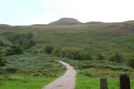
Sgorr na Ciche, better known as the Pap of Glencoe, is a pointed summit recognisable from just about anywhere in the Glencoe region due to the lack of surrounding hills. Please note this is one of the wettest parts of Britain so good planning is essential if you wish to avoid the weather.
There are plenty of parking options in Glencoe village although some places can be found along the tiny road leading east out the village. Once you have parked the car head for Tom Braec 800m short of Leacantuim. Take the large path northwest from the road through the gate and follow up the hill (not marked on all OS maps).
Immediately you gain altitude as the path turns right and heads for the small dam at Grid ref. NN116585 with, even at this early stage of the walk, rewarding views of Loch Leven and Glencoe village. Continue past the dam and across the hillside heading towards the left of the Pap. After a somewhat hard hour or so the base of this small giant is reached. The way up to the summit is obvious as the path corkscrews around the back taking you to the summit in a zigzag fashion. Once on top you can take in stunning views of Loch Leven and Glencoe directly at your feet! To the south the lost valley of Glencoe can also be made out as you go wild with the camera! This is one of Scotland's most rewarding viewpoints under 800m.
When ready exit the summit to the east where the path leads you down directly towards the village. Within 500m the track joins the right side of the river at grid ref. NN119594 where you simply make your way down the hillside. In summer expect the route to be quite overgrown in places with thick bracken making the journey interesting! Eventually a very small dam is reached, pass this and rejoin the main track once again back to the road to complete a simple, but pleasant way to the summit of the Pap of Glencoe.
Other walks nearby
| Walk 3118 | Sgor na h'Ulaidh from Achnachon, Glen Coe | mod/hard | 8.0 miles |
| Walk 2955 | Ridges & peaks of Bidean Nam Bian | very hard | 10.5 miles |
| Walk 2554 | The Lost Valley, Glen Coe | easy/mod | 4.2 miles |
| Walk 3251 | Bidean nam Bian via Stob Coire nan Lochan, Glencoe | hard | 5.0 miles |
| Walk 1496 | WHW - Day 6 - Kinlocheven to Fort William | moderate | 15.0 miles |
| Walk 3106 | Binnein Mor from Kinlochleven | hard | 10.2 miles |
| Walk 1039 | Am Bodach and Stob Coire a' Chairn | mod/hard | 9.5 miles |
| Walk 1094 | Blackwater Reservoir | moderate | 11.5 miles |
| Walk 2808 | Buachaille Etive Beag, Glen Coe | hard | 9.0 miles |
| Walk 3303 | Mamores Ridge - Stob Ban, Am Bodach and Sgurr an Iubhair | hard | 9.0 miles |
Recommended Books & eBooks
Great Mountain Days in Scotland
 Inspirational guidebook to 50 challenging routes for mountaineers, scramblers, hillwalkers and fell runners, many long enough to backpack over 2 days, especially in winter (12 to 25 miles). A mix of classic routes and unsung gems across Scotland from Galloway to the Outer Hebrides in widely differing wild landscapes. With customised OS mapping.
More information
Walking in Torridon
 This guidebook contains 52 day walks in Torridon, a remote and much-loved area of the Scottish Highlands. Based around Shieldaig and Slioch, the routes are split into 3 sections: easy walks, long and high level walks and mountain ascents over 2000ft including 9 Munros, and 5 outline suggestions for major ridge walks.
More information
Messaging & Social Media
Message Walking Britain and follow the latest news.

Mountain Weather
Stay safe on the mountains with detailed weather forecasts - for iOS devices or for Android devices.