The Norber Erratics & Sulber Gate from Austwick
Yorkshire Dales Walk
Nat Park - Yorkshire Dales - Lower Ribblesdale
County/Area - North Yorkshire
Author - Lou Johnson
Length - 8.0 miles / 13 km Ascent - 1375 feet / 417 metres
Time - 5 hours 20 minutes Grade - moderate
Walk Route Description
Click image to visit gallery of 9 images.
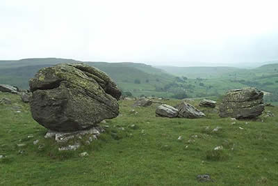
The south-western sector of the Yorkshire Dales National Park is noted for its interesting limestone scenery. This walk includes some superb examples and in addition includes the Norber Erratics. Of great geological interest, these large rocks were transported by glaciers and left stranded far their home when the glaciers retreated due to global warming.
This Yorkshire Dales walk starts from the village of Austwick just north of the main A65 trunk road. There is plenty of on-street parking in the village although please make sure that you are not causing an obstruction to local residents before you start on the walk. Starting from outside the school (grid ref. SD769686) head northwest along the road to Horton and take the first lane on your left. Austwick Hall is on your left as climb out of the village. Just as the lane levels turn left into Thwaite Lane (Grid ref. SD769692). After a short way take the signed footpath on your right across fields towards the limestone outcrops of Robin Proctor's Scar. Crossing a stile continue ahead to a fourway signpost (grid ref. SD766697). Continue straight ahead climbing up a cleft in the crags to reach a large area where the majority of the Norber Erratics can be found.
There are many large boulders perched on limestone plinths and they were transported some distance by glaciers. After inspecting the Erratics return to the fourway fingerpost and turn right signed to 'Clapham'. Skirt across the foot of Robin Proctor's Scar and cross a large pasture to rejoin Thwaite Lane. Turn right along the lane and continue towards Clapham. At the junction (Grid ref. SD751694) turn right into Long Lane. This walled track takes you north with views of the entrance to Ingleborough Cave and Trow Gill to your left. Reaching the gate at the top of the lane (Grid ref. SD758716) bear right and follow the clear track that climbs gently towards Long Scar.
There are many tracks across this upland area and it is hard to describe the exact route. However providing you follow a generally northeasterly route you will arrive safely at Sulber Gate (Grid ref. SD775731). Go through the large gate and locate a smaller gate in the right hand wall. Go through this and descend steeply onto the large limestone pavement known as Thieves Moss. The onward path is unclear but you need to locate Beggar's Stile (Grid ref. SD777726) from where a clearer path leads through Crummack Dale to Crummack Farm. Should you fail to locate Beggar's Stile there is another stile (Grid ref. SD775729) that could also be used to descend to Crummack Farm.
Keep to the right of the farm on a clearly marked bridleway. This leads into an unsurfaced walled lane from where there are pleasant views of the Dale. Eventually the lane changes to tarmac and this leads down without any further problems into Austwick village.
Maps 

| Ordnance Survey Explorer OL2 | Sheet Map | 1:25k | BUY |
| Anquet OS Explorer OL2 | Digital Map | 1:25k | BUY |
| Ordnance Survey Digital Map Subscription | |||
| Latest Ordnance Survey Discounts | |||
Other walks nearby
| Walk 1248 | Trow Gill, Ingleborough & Long Scar | moderate | 9.5 miles |
| Walk 2796 | Ingleborough via Gaping Gill & Norber | moderate | 13.0 miles |
| Walk 3599 | Clapham, Oxenber Woods, Feizor & Settle | easy/mod | 7.5 miles |
| Walk 3094 | Norber & Norber Erractics | easy/mod | 6.3 miles |
| Walk 2649 | Attermire Scar & Malham Tarn from Stainforth | mod/hard | 16.5 miles |
| Walk 1121 | Pen-y-ghent & Plover Hill | moderate | 9.0 miles |
| Walk 1013 | Pen-y-ghent | moderate | 6.5 miles |
| Walk 1500 | Pen-y-ghent via Horton Scar | moderate | 6.8 miles |
| Walk 3433 | Yorkshire Three Peaks | very hard | 24.5 miles |
| Walk 2617 | Nappa Cross & Victoria Cave from Langcliffe | moderate | 9.5 miles |
Recommended Books & eBooks
Walking in the Yorkshire Dales: South and West
 Part of a two-book set, this guidebook describes 44 walks in the southern and western Yorkshire Dales, including the famous 23 mile Three Peaks circuit over Pen-y-Ghent, Whernside and Ingleborough. The other, mostly circular routes of 3½ to 13 miles cover the scenic region between Sedbergh, Kirkby Lonsdale, Settle, Skipton and Grassington.
More information
Trail and Fell Running in the Yorkshire Dales
 Guidebook to 40 of the best trail and fell runs in the Yorkshire Dales National Park. Ranging from 5 to 24 miles, the graded runs start from bases such as Ribblehead, Dent, Sedbergh, Malham and Grassington and take in the region's diverse delights, from castles and waterfalls to iconic mountains such as Whernside, Ingleborough and Pen Y Ghent.
More information
