Walk 1251 - printer friendly version
The Norber Erratics & Sulber Gate Walk
Author - Lou Johnson
Length - 8.0 miles / 13 km
Ascent - 1375 feet / 417 metres
Grade - moderate
Start - OS grid reference SD769687
Lat 54.11365 + Long -2.3548531
Postcode LA2 8BP (approx. location only)
The south-western sector of the Yorkshire Dales National Park is noted for its interesting limestone scenery. This walk includes some superb examples and in addition includes the Norber Erratics. Of great geological interest, these large rocks were transported by glaciers and left stranded far their home when the glaciers retreated due to global warming.
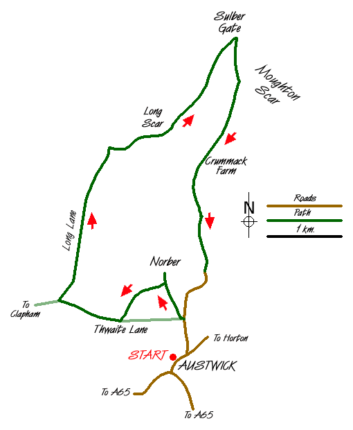
This Yorkshire Dales walk starts from the village of Austwick just north of the main A65 trunk road. There is plenty of on-street parking in the village although please make sure that you are not causing an obstruction to local residents before you start on the walk. Starting from outside the school (grid ref. SD769686) head northwest along the road to Horton and take the first lane on your left. Austwick Hall is on your left as climb out of the village. Just as the lane levels turn left into Thwaite Lane (Grid ref. SD769692). After a short way take the signed footpath on your right across fields towards the limestone outcrops of Robin Proctor's Scar. Crossing a stile continue ahead to a fourway signpost (grid ref. SD766697). Continue straight ahead climbing up a cleft in the crags to reach a large area where the majority of the Norber Erratics can be found.
There are many large boulders perched on limestone plinths and they were transported some distance by glaciers. After inspecting the Erratics return to the fourway fingerpost and turn right signed to 'Clapham'. Skirt across the foot of Robin Proctor's Scar and cross a large pasture to rejoin Thwaite Lane. Turn right along the lane and continue towards Clapham. At the junction (Grid ref. SD751694) turn right into Long Lane. This walled track takes you north with views of the entrance to Ingleborough Cave and Trow Gill to your left. Reaching the gate at the top of the lane (Grid ref. SD758716) bear right and follow the clear track that climbs gently towards Long Scar.
There are many tracks across this upland area and it is hard to describe the exact route. However providing you follow a generally northeasterly route you will arrive safely at Sulber Gate (Grid ref. SD775731). Go through the large gate and locate a smaller gate in the right hand wall. Go through this and descend steeply onto the large limestone pavement known as Thieves Moss. The onward path is unclear but you need to locate Beggar's Stile (Grid ref. SD777726) from where a clearer path leads through Crummack Dale to Crummack Farm. Should you fail to locate Beggar's Stile there is another stile (Grid ref. SD775729) that could also be used to descend to Crummack Farm.
Keep to the right of the farm on a clearly marked bridleway. This leads into an unsurfaced walled lane from where there are pleasant views of the Dale. Eventually the lane changes to tarmac and this leads down without any further problems into Austwick village.
Messaging & Social Media
Message Walking Britain and follow the latest news.

Mountain Weather
Stay safe on the mountains with detailed weather forecasts - for iOS devices or for Android devices.