Yockenthwaite & Hubberholme from Buckden
Yorkshire Dales Walk
Nat Park - Yorkshire Dales - Upper Wharfedale
County/Area - North Yorkshire
Author - Lou Johnson
Length - 8.0 miles / 13 km Ascent - 560 feet / 170 metres
Time - 4 hours 30 minutes Grade - moderate
Walk Route Description
Click image to visit gallery of 9 images.
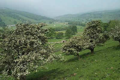
This Yorkshire Dales walk combines an outward leg along a limestone escarpment to Yockenthwaite with a return route alongside the River Wharfe via Hubberholme using the Dales Way. Taking in the head of Wharfedale and lower Langstrothdale it provides the walker with plenty of interest and some fine 'Dales' scenery. On those days when Buckden Pike is clothed in cloud this walk provides a wonderful substitute despite its relatively low level.
The start is the large carpark in Buckden (Grid ref. SD942773). After parking take the northern exit and follow the track rising through Rakes Wood to join Buckden Rake. This is followed north to Cray High Bridge where the road is joined. Turn left and descend along the road and just before the Inn (grid ref. 942792) turn right following the signed path to Scar House that runs west.
The next section is delightful with grass underfoot and superb views down Wharfedale. Note the cairn to the right of the path (Grid ref. 929788) from where the definitive view down Wharfedale can be enjoyed. The going remains easy as you approach Scar House from where it is possible to shorten the route by descending directly to Hubberholme.
However we leave Scar House and continue on the high level path passing through a short section of deciduous woodland to cross a number of small fields. The path then descends to Yockenthwaite where a fine bridge spans the River Wharfe. Just before reaching the river turn left along the Dales Way. The path is good, the views excellent and progress fast as you head downstream to Hubberholme.
The church tower comes into view before the rather squat but picturesque church can be fully enjoyed. A visit is recommended before crossing the Wharfe and following the road towards Buckden. It is a pity that the Dales Way does not cross the fields on this section as the road is quite narrow and can be busy at peak times. However the road walking is short lived and you turn left along a signed path to rejoin the river bank for the final section back to Buckden.
Note :- The photos for this walk description were taken during early June when the wildflower meadows are near their best. Even a non-botanist will soon realise that there are more than a dozen types of wild flowers. With encouragement from the National Park Authority and other interested parties the superb displays of wild flowers have become more widespread as farmers delay harvesting their hay meadows.
Maps 

| Ordnance Survey Explorer OL30 | Sheet Map | 1:25k | BUY |
| Anquet OS Explorer OL30 | Digital Map | 1:25k | BUY |
| Ordnance Survey Digital Map Subscription | |||
| Latest Ordnance Survey Discounts | |||
Other walks nearby
| Walk 1926 | Pen-y-ghent & Littondale | hard | 16.0 miles |
| Walk 1250 | Great Whernside | moderate | 8.0 miles |
| Walk 1277 | Starbotton & Kettlewell circular | easy/mod | 5.0 miles |
| Walk 1294 | Arncliffe & Kettlewell Circular | moderate | 7.0 miles |
| Walk 1632 | Arncliffe & Starbotton from Kettlewell | moderate | 7.0 miles |
| Walk 1278 | Cosh & Foxup | easy/mod | 6.5 miles |
| Walk 2332 | Mastilles Lane & Bordley from Kilnsey | easy/mod | 6.8 miles |
| Walk 3392 | Darnbrook Fell & Fountains Fell | moderate | 6.4 miles |
| Walk 2265 | Semer Water, Stalling Busk & Marsett | easy | 4.0 miles |
| Walk 3301 | Conistone to Grassington via the Dib | easy | 5.0 miles |
Recommended Books & eBooks
Walking in the Yorkshire Dales: South and West
 Part of a two-book set, this guidebook describes 44 walks in the southern and western Yorkshire Dales, including the famous 23 mile Three Peaks circuit over Pen-y-Ghent, Whernside and Ingleborough. The other, mostly circular routes of 3½ to 13 miles cover the scenic region between Sedbergh, Kirkby Lonsdale, Settle, Skipton and Grassington.
More information
The Dales Way
 An essential guidebook to walking the Dales Way. This picturesque 78 mile long distance route through the Yorkshire Dales between Ilkley and Bowness on Windermere is one of the gentlest multi-day walks in Britain. The route is described in both directions, visiting Grassington, Kettlewell, Buckden, Dent, Sedbergh and Staveley en route to Bowness.
More information
