Cosh & Foxup from Halton Gill
Yorkshire Dales Walk
Nat Park - Yorkshire Dales - Upper Wharfedale
County/Area - North Yorkshire
Author - Lou Johnson
Length - 6.5 miles / 10.6 km Ascent - 1000 feet / 303 metres
Time - 4 hours 20 minutes Grade - easy/mod
Walk Route Description
Click image to visit gallery of 6 images.
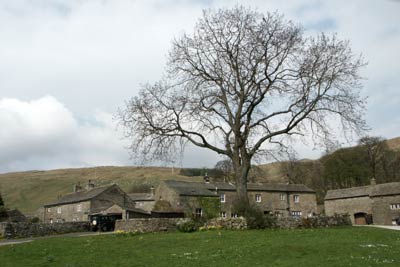
This Yorkshire Dale walk explores the upper reaches of Littondale and provides contrasting scenery in a relatively short distance. The start is the small parking area at the attractive hamlet of Halton Gill (Grid ref. SD880764) where a courtesy box requests donations for parking.
From the parking area walk towards the road junction and turn right in the direction of Settle. Follow the lane downhill to the bridge over the River Skirfare. Once across the bridge turn right on the signed footpath. This leads alongside the river to the road at Foxup Bridge. Turn right crossing the river and immediately left along a track (Grid ref. SD 872767).
This track is followed for about two kilometres to reach the isolated farm at Cosh. The scenery on this section of the walk has a wild moorland character. As you near Cosh look out for some sheepfolds on your left (Grid ref. SD 862780). Descend over rough ground past the sheepfold and cross Cosh Beck. There is a gated stile that leads you onto a path, which can be seen from the track as you approach from Foxup Bridge.
Follow this path across fields and past stone barns. At a junction of paths continue ahead to reach a lane at Foxup (Grid ref. 869767). Turn left down the lane and take the signed bridleway on your right (just opposite Foxup Farm). This track climbs across fields before levelling out to give good views across Littondale to the hamlet of Halton Gill.
After passing a small limestone pavement the track reaches a road (Grid ref. SD 878749) at Hesleden Bergh. Turn left and descend to Halton Gill Bridge after which a there is a short climb up the lane back to the start.
Maps 

| Ordnance Survey Explorer OL2 | Sheet Map | 1:25k | BUY |
| Anquet OS Explorer OL2 | Digital Map | 1:25k | BUY |
| Ordnance Survey Digital Map Subscription | |||
| Latest Ordnance Survey Discounts | |||
Other walks nearby
| Walk 1926 | Pen-y-ghent & Littondale | hard | 16.0 miles |
| Walk 3392 | Darnbrook Fell & Fountains Fell | moderate | 6.4 miles |
| Walk 1254 | Yockenthwaite & Hubberholme | moderate | 8.0 miles |
| Walk 1281 | Buckden Pike | moderate | 10.5 miles |
| Walk 2132 | Buckden Pike and Hubberholme | moderate | 8.4 miles |
| Walk 2493 | Cow Close Gill Waterfalls | easy/mod | 4.6 miles |
| Walk 1121 | Pen-y-ghent & Plover Hill | moderate | 9.0 miles |
| Walk 1013 | Pen-y-ghent | moderate | 6.5 miles |
| Walk 1500 | Pen-y-ghent via Horton Scar | moderate | 6.8 miles |
| Walk 3433 | Yorkshire Three Peaks | very hard | 24.5 miles |
Recommended Books & eBooks
Trail and Fell Running in the Yorkshire Dales
 Guidebook to 40 of the best trail and fell runs in the Yorkshire Dales National Park. Ranging from 5 to 24 miles, the graded runs start from bases such as Ribblehead, Dent, Sedbergh, Malham and Grassington and take in the region's diverse delights, from castles and waterfalls to iconic mountains such as Whernside, Ingleborough and Pen Y Ghent.
More information
Walking in the Yorkshire Dales: North and East
 This guidebook contains 43 circular day walks in the north and east Yorkshire Dales. It explores the dales, hills and moors between Kirkby Stephen and Pateley Bridge. Walking ranges from gentle 3 mile strolls to more strenuous day-long rambles across the Howgills, Wensleydale, Swaledale, Nidderdale, Mallerstang and Coverdale.
More information
