Walk 1339 - printer friendly version
High Cup Nick Walk
Author - Lou Johnson
Length - 10.5 miles / 17.1 km
Ascent - 1400 feet / 424 metres
Grade - moderate
Start - OS grid reference NY689249
Lat 54.618284 + Long -2.4831188
Postcode CA16 6DE (approx. location only)
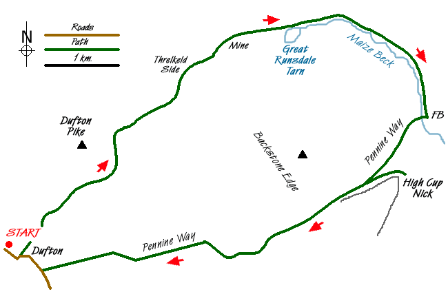
This is a "five star" route that includes interesting geology, wild moorland and fantastic views all contained in a few square miles of the North Pennines. One word of warning is that the section from Great Runsdale Tarn to the bridge on the Pennine Way over Maize Beck could be very wet underfoot after rain with an added risk of flash floods. Care is therefore needed. Despite this warning, crossing this desolate moorland is easy from a navigational point of view provided you do not stray from the beck.
The start is the attractive village of Dufton (Grid ref. NY689249) a few miles north along a minor road from the A66 at Appleby-in-Westmoreland. There is a small car park, a pub, village store and tearoom together with public toilets. Exit the car park and walk back towards Appleby (south) following the road around to the left. Where the lane turns right walk straight ahead along a lane. Keep to the right where the track divides (Grid ref. NY 691 252) and with improving views ahead climb steadily with conically shaped Dufton Pike to your left.
Having reached a col due east of Dufton Pike the track descends slightly before entering a deep steep sided valley where evidence of former mine working can be seen. The track continues to climb but never steeply into the narrowing valley. Stay on the track past a section that has seen recent reconstruction towards a shooting cabin. From here the northern shore of Great Runsdale Tarn is just over a hundred metres south.
Turn left along the shore and locate the outflow. This is Maize Beck and needs to be followed downstream for approximately 2.5 km. There is a path of sorts and it will probably be fairly damp underfoot so be prepared for some "bog trotting". The view ahead across some of the wildest moors in England is dominated by the whaleback of Mickle Fell.
Reaching a footbridge over Maize Beck means that you have reached the Pennine Way. Turn right (southwest) to follow this National Trail, which is marked by posts, across a limestone pavement to reach spectacular High Cup Nick. This is where the Whin Sill, which is formed of blue-grey dolerite, has provided extra resistance to glaciers and formed one of the most spectacular natural features in the UK.
After spending some time taking in the view, which on my last visit included every peak in Lakeland, follow the wide path along the northern rim. This is again the Pennine Way and is followed all the way back to Dufton. On reaching the road through the village, turn right and follow it back to the start.
Messaging & Social Media
Message Walking Britain and follow the latest news.

Mountain Weather
Stay safe on the mountains with detailed weather forecasts - for iOS devices or for Android devices.