Walk 1344 - printer friendly version
Beinn Alligin & Sgurr Mor Walk
Author - Lou Johnson
Length - 6.0 miles / 9.8 km
Ascent - 4100 feet / 1242 metres
Grade - mod/hard
Start - OS grid reference NG868576
Lat 57.558053 + Long -5.5656187
Postcode IV22 2HA (approx. location only)
Beinn Alligin is probably the easiest ascent of the Torridon Munros. It occupies a solitary position to the west of Liathach and, in good weather, provides a grandstand view of the surrounding mountains, lochans and coast.
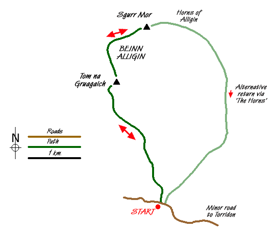
The start is a small car park (Grid ref. NG868576) on the south side of the road from the A896 at Torridon village that leads west to Lower Diabaig. After parking cross the road and locate the path that starts just to the west of the river bridge. If my memory can be relied on the start was obscured by a shrub! The onward path crosses rough grassland with some boggy sections, which can be avoided.
The climb at first is very gentle rising to rocky outcrops that provide some simple scrambling before another section of gentle ascent to another rocky outcrop which continues most of the way to the foot of the large coire, Coir nan Laogh, that can be seen ahead. Once this steep sided bowl is reached the path steepens and continues roughly following the burn. Despite the steepness, upward progress is fast and you soon arrive at a broad col. Turn right and continue to the summit of Tom na Gruagaich (922 m) which is the first Munro of the day.
Looking northeast you will the next objective, Sgurr Mor, and you will soon realise that there is still some hard work to do! The descent from Tom na Gruagaich is fine apart from one rocky section which is hard in descent. One this has been passed it is a straightforward "yomp" to Sgurr Mor with a very impressive gully passed on your right had side not far from the summit cairn.
Fron here you have two alternatives. You can either descend the way you came on which this walk is based or you can continue over the Horns of Alligin which can be seen below. The latter does involve some steep descents that are loose underfoot. However you do have the benefit of not covering the same ground twice.
For those following this route return whence you came dropping down to the col before Tom na Gruagaich before ascending just over 500 feet to the summit. From here walk west about 200 metres before bearing left for the descent into the Coir na Laogh. If in doubt locate the burn and follow it down. All that remains is the walk across the moor with the intervening rocky outcrops to negotiate.
Messaging & Social Media
Message Walking Britain and follow the latest news.

Mountain Weather
Stay safe on the mountains with detailed weather forecasts - for iOS devices or for Android devices.