Beinn Alligin & Sgurr Mor
Highland Walk
County/Area - Highland - Central Highland
Author - Lou Johnson
Length - 6.0 miles / 9.8 km Ascent - 4100 feet / 1242 metres
Time - 7 hours 10 minutes Grade - mod/hard
Walk Route Description
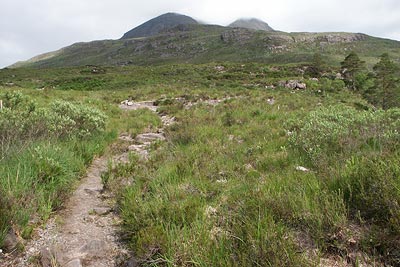
Click image to visit gallery of 9 images.
Beinn Alligin is probably the easiest ascent of the Torridon Munros. It occupies a solitary position to the west of Liathach and, in good weather, provides a grandstand view of the surrounding mountains, lochans and coast.
The start is a small car park (Grid ref. NG868576) on the south side of the road from the A896 at Torridon village that leads west to Lower Diabaig. After parking cross the road and locate the path that starts just to the west of the river bridge. If my memory can be relied on the start was obscured by a shrub! The onward path crosses rough grassland with some boggy sections, which can be avoided.
The climb at first is very gentle rising to rocky outcrops that provide some simple scrambling before another section of gentle ascent to another rocky outcrop which continues most of the way to the foot of the large coire, Coir nan Laogh, that can be seen ahead. Once this steep sided bowl is reached the path steepens and continues roughly following the burn. Despite the steepness, upward progress is fast and you soon arrive at a broad col. Turn right and continue to the summit of Tom na Gruagaich (922 m) which is the first Munro of the day.
Looking northeast you will the next objective, Sgurr Mor, and you will soon realise that there is still some hard work to do! The descent from Tom na Gruagaich is fine apart from one rocky section which is hard in descent. One this has been passed it is a straightforward "yomp" to Sgurr Mor with a very impressive gully passed on your right had side not far from the summit cairn.
Fron here you have two alternatives. You can either descend the way you came on which this walk is based or you can continue over the Horns of Alligin which can be seen below. The latter does involve some steep descents that are loose underfoot. However you do have the benefit of not covering the same ground twice.
For those following this route return whence you came dropping down to the col before Tom na Gruagaich before ascending just over 500 feet to the summit. From here walk west about 200 metres before bearing left for the descent into the Coir na Laogh. If in doubt locate the burn and follow it down. All that remains is the walk across the moor with the intervening rocky outcrops to negotiate.
Maps 

| Ordnance Survey Explorer 433 | Sheet Map | 1:25k | BUY |
| Anquet OS Explorer 433 | Digital Map | 1:25k | BUY |
| Ordnance Survey Digital Map Subscription | |||
| Latest Ordnance Survey Discounts | |||
Other walks nearby
| Walk 2593 | Liathach, Glen Torridon | very hard | 8.5 miles |
| Walk 2116 | Beinn Eighe Route Guide | hard | 13.0 miles |
| Walk 2117 | Beinn Eighe - West to East traverse, Torridon | hard | 12.3 miles |
| Walk 2118 | Beinn Eighe traverse including Black Carls, Torridon | hard | 12.5 miles |
| Walk 2119 | Beinn Eighe - The Munros & Sail Mhor, Torridon | hard | 13.0 miles |
| Walk 2120 | The Munros of Beinn Eighe, Torridon | hard | 10.8 miles |
| Walk 3268 | Loch Coire Mhic Fhearchair (Beinn Eighe) | moderate | 8.3 miles |
| Walk 1347 | Meall a' Ghiubhais from Kinlochewe | moderate | 8.0 miles |
| Walk 1305 | Sgurr nan Fhir Duibhe from Kinlochewe | hard | 7.5 miles |
| Walk 2693 | Achnashellach & Easan Dorcha | moderate | 8.8 miles |
Recommended Books & eBooks
Walking the Munros Vol 2 - Northern Highlands and the Cairngorms
 Guidebook to walking the northern Munros, covering the northern Highlands, the Cairngorms and the Isle of Skye. 70 routes are described, including those up Ben Macdui, Braeriach and Cairn Gorm. Routes range from 7 to 46km, requiring a fair level of fitness. The second of two guidebooks to walking Scotland's Munros: peaks higher than 3000ft.
More information
Skye's Cuillin Ridge Traverse
 This 2-volume set provides all the information required to complete the main ridge traverse on Skye's Black Cuillin. Strategy, gear, training, navigation and logistics are covered, and 10 classic scrambles are described. A lightweight second guidebook gives the scrambler detailed maps, topos and route description for the ridge traverse itself.
More information
