Walk 1384 - printer friendly version
Mallerstang Edge Walk
Author - Lou Johnson
Length - 8.8 miles / 14.2 km
Ascent - 1300 feet / 394 metres
Grade - moderate
Start - OS grid reference SD778962
Lat 54.360836 + Long -2.3431319
Postcode CA17 4JY (approx. location only)
This walk in the upper reaches of the Eden Valley ascends the escarpment lying on the east side of the valley. The route includes some pathless sections and a good sense of direction and suitable maps are recommended. There is some steep ascent involved although you are rewarded by some fine views of Mallerstang, Wild Boar Fell and the surrounding area. Notes also included on visiting two summits, Archy Styrigg and High Seat.
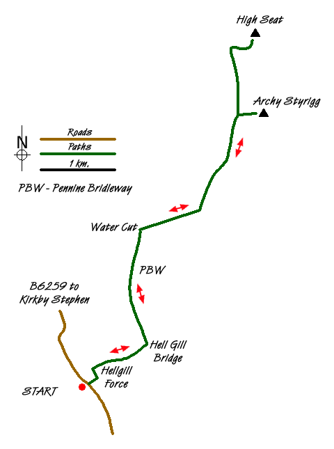
The start is Aisgill Moor Cottages (grid ref SD778962) where limited parking is available in the vicinity. An alternative approach is given in the final paragraph of this description. After parking leave the road and cross the railway bridge following the clear track to the first junction (grid ref. SD778965). It is worth spending a few minutes diverting to Hell Gill Force which can be very dramatic after heavy rain. Turn right here along another track and make your way up to Hellgill and beyond to the Pennine Bridleway (grid ref. SD786968).
Turn left along the Pennine Bridleway with the wall on your left. Where the wall ends and descends into the valley keep ahead to the "Water Cut" sculpture (grid ref. SD785985). This the first (or last) of a number of sculptures along the Eden Valley. The next objective is Raven's Nest (grid ref. SD794990), which lies roughly north east of the sculpture. Using a mixture of sheep trods and rough pasture the ascent proved easier than it looked picking up a clear path running along the edge.
The views from the edge are superb with Wild Boar Fell across the valley capturing your attention. Closer to hand the rocky outcrops forming the edge are impressive. Continue on the clear path which undulates above Hangingstone Scar and continues to High Loven Scar. The summit of Archy Styrigg lies to the east of the latter and can be reached by sheep trods and a path from the main path along the edge.
Continuing north along what has become a less distinct edge, you can also 'bag' the summit of High Seat, which is the highest point on this side of the Eden Valley. Describing the route is difficult but by heading east along Sloe Brae Gill and then striking off north to the summit worked well. Luckily there had been little rain in the preceding weeks so be prepared for some wet ground after rain.
To return to the start retrace your steps. Remember that if cloud descends then navigation can be problematic and careful use of maps and a compass might be necessary.
An alternative start is the small car park at grid ref. NY783004 near The Thrang. From here take Pennine Bridleway as it ascends the eastern flank of Mallerstang. This leads up to the "Water Cut" sculpture from here the description given above should be followed.
Messaging & Social Media
Message Walking Britain and follow the latest news.

Mountain Weather
Stay safe on the mountains with detailed weather forecasts - for iOS devices or for Android devices.