Walk 1389 - printer friendly version
Fell End Clouds Walk
Author - Lou Johnson
Length - 3.0 miles / 4.9 km
Ascent - 550 feet / 167 metres
Grade - easy
Start - OS grid reference NY733005
Lat 54.399262 + Long -2.4127665
Postcode CA17 4LL (approx. location only)
This easy walk explores an area of limestone country that adjoins the western slopes of Wild Boar Fell. Besides the immediate interest provided by the limestone outcrops and pavements you get some fine views across the surrounding countryside including the Eden Valley, the Howgill Fells and northern slopes of Baugh Fell which lies above Dentdale.
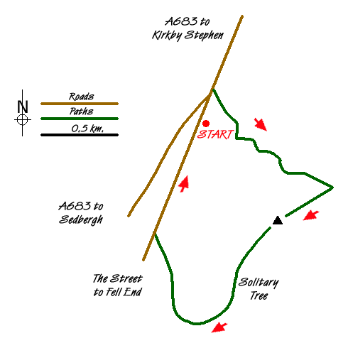
The start is at grid ref NY734005 where parking is available in an old quarry on the minor road formerly known as "the Street". This minor road is signed Ulldale and Fell End off the A683 Sedbergh to Kirkby Stephen Road. After parking walk towards the main road. On your right there is a stone wall. Leave the minor road just before the wall and follow a track that twists and turns up towards a ridge. In places the track is rather vague but it becomes more obvious as height is gained. The OS Explorer map provides good guidance. As you climb the views improve with the track eventually reaching a col (grid ref. NY742001). Ahead lies rough moorland that forms the western slopes of Wild Boar Fell.
Turn right (southwest) along the ridge aiming for a large prominent cairn. Across the valley to your right lie the Howgill Fells with Harter Fell the dominant summit in the foreground. Beyond you can see the hump backed hills that are so typical of the Howgills. There is no clear path along the ridge. However the going is easy and navigation is not a problem. Around you are some fine limestone pavements with the landscape typical of limestone country. Reaching the cairn you can fully appreciate the delights of Fell End Clouds and their wonderful position.
To continue walk towards the large solitary tree that lies south west. Be careful as there is clear evidence of mining activity in this area with some deep trenches cut into the hillside. Reaching the tree continue your descent maintaining a similar direction towards the stone wall ahead. You will soon locate a clear track that heads northwest. Follow this track descending to the minor road passing two fine examples of limestone kilns on your right.
Reaching the minor road, turn right and walk back along this quiet lane back to the start.
Messaging & Social Media
Message Walking Britain and follow the latest news.

Mountain Weather
Stay safe on the mountains with detailed weather forecasts - for iOS devices or for Android devices.