Walsden & Warland Reservoir
South Pennines Walk
Region - South Pennines
County/Area - West Yorkshire - Calderdale
Author - Allan Friswell
Length - 6.5 miles / 10.6 km Ascent - 1000 feet / 303 metres
Time - 4 hours 20 minutes Grade - easy/mod
Walk Route Description
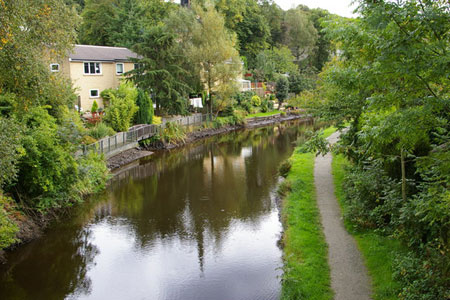
Click image to visit gallery of 5 images.
This walk explores some of the high ground above Calderdale. The route includes some steady climbing for about a mile from the canal to Warland reservoir. Once the high ground has been gained you can relax and enjoy the views. The start is Hollins Road. Walsden (Grid ref. SD934221). If coming from Todmorden on the A6033 Todmorden to Rochdale road, Hollins Road is after the A681 Bacup road forks off to the right. Opposite the prefabricated Walsden Library on the right is a road signposted Lumbutts and Mankinholes. This is Hollins Road. Please park with consideration for local residents.
After parking walk up Hollins Road to the canal bridge. Drop down the ginnel to the towpath, turn right, under the bridge and proceed ahead toward Winterbutlee lock. Accompany the beautiful and isolated rural towpath for about a mile and a quarter until you come to a little stone bridge in open country with the walls of Warland high up on the left on the other side of the canal. Cross the bridge and take the path through the well disguised gate climbing to the right on the left of a wall. This bears left to a gate at the top corner of the field, with the walls of Warland looming over you. Cross the gate and accompany the wall along into a short ginnel leading to a road.
Cross over and continue on the road leading uphill. You come to a fork - keep ahead through the side gate and proceed up the tarmacked drive, passing a house, some noisy dogs and an extraordinary number of parked cars on the way up. Keep on the track that bears right behind the isolated farm, through a gate and on left up the hill. When you arrive at the foot of the reservoir embankment, leave the track and climb the embankment by a narrow path slanting to the left. At the top turn left along the track beside Warland Reservoir. You are now on the Pennine Way. Continue on this track past the end of the reservoir and on the left of a culvert, ignoring a tempting path with beguiling yellow markers. Soon after, where the track bends right, (grid ref. SD955217) leave the Pennine Way, and proceed left on a clear slabbed path along the left bank of a large ditch. In due time this path bears left and then right to take you along the embankment of Gaddings Reservoir. Look out for the proud outline of Stoodley Pike to your right, and the wind farm of Ovenden Moor (Yorkshire's biggest) ahead in the distance.
At the far corner of the embankment take the obvious path dropping half-left. Follow it down. You pass the Basin Stone on your way at grid ref. SD944223. The Basin Stone is a natural weathered outcrop of millstone grit on Walsden Moor, part of Langfield Common, not far from Gaddings Dam. Ideally shaped for pulpit use, The stone was the location of radical meetings of the Chartists, Hudsonites and later Socialist groups. On August 18th 1842, following the Plug Riots in Halifax Ben Rushton addressed a large Chartist meeting at Basin Stone. A painting of this scene by AW Bayes hangs in Todmorden Town Hall. Presently, after crossing a causeyed path (The Mary Townley Loop / Pennine Bridleway) the path develops into a broad track and curves right down to a wall. At this point a suspension of disbelief comes in handy. Turn back left keeping the wall on your right. Follow the wall for about 200 yards. This is tricky. The path is generally unwalked, there are boggy areas, but it is the right path!
Go over the stile at grid ref. SD935227 initially alongside, then within a walled green lane leading to a large farm. Go through its gate and pass to the right of the building. Where the path diverges, head left, and follow this as it zigzags downhill. This brings you out at Chapel Top at grid ref. SD931228. Turn left and walk to the T junction, then ahead and drop down right to the main road. Turn left over the canal bridge, gain the towpath via the ginnel, and follow it bridge 34, where you climb to the road and turn right in Hollins Lane once more to regain your car.
Maps 

| Ordnance Survey Explorer OL21 | Sheet Map | 1:25k | BUY |
| Anquet OS Explorer OL21 | Digital Map | 1:25k | BUY |
| Ordnance Survey Digital Map Subscription | |||
| Latest Ordnance Survey Discounts | |||
Other walks nearby
| Walk 3719 | Ramsden Wood & Hades Hill from Walsden | easy/mod | 6.1 miles |
| Walk 3015 | Stoodley Pike & Withens Clough Reservoir from Lobb Mill | moderate | 9.0 miles |
| Walk 1849 | Blackstone Edge and the Pennine Way without a car | moderate | 8.0 miles |
| Walk 2260 | White Hill from Hollingworth Lake | moderate | 11.2 miles |
| Walk 2606 | Hoof Stones Height, Noah Dale and Colden Water | moderate | 11.5 miles |
| Walk 1458 | The Rossendale Way from Greave | easy/mod | 7.0 miles |
| Walk 2183 | Irwell Sculpture Trail | easy | 4.5 miles |
| Walk 3380 | Blackstone Edge from Hollingworth Lake | moderate | 9.0 miles |
| Walk 1291 | Stoodley Pike | moderate | 11.0 miles |
| Walk 2121 | Crimsworth Dean, Lumb Bridge & Hardcastle Crags | moderate | 7.5 miles |
Recommended Books & eBooks
The Pennine Way
 Guidebook to the Pennine Way National Trail with OS map booklet. The 265 mile route from Edale to Kirk Yetholm takes three weeks to walk and is suitable for fit and experienced long distance walkers. The route crosses the Peak District, Yorkshire Dales and North Pennines National Parks. Includes separate OS 1:25,000 map booklet of the route.
More information
The Pennine Way - the Path, the People, the Journey
 A portrait of the The Pennine Way, Britain's oldest and best known long-distance footpath, stretching 268 miles from the Peak District to the Scottish Borders. This personal, thoughtful and often humorous story of the path's remarkable history, includes the experiences of walkers and local characters on this exhilarating and complex path.
More information
