Borth to Aberystwyth coast
Ceredigion Walk
County/Area - Ceredigion
Author - Christiane Kloos
Length - 6.5 miles / 10.6 km Ascent - 1300 feet / 394 metres
Time - 4 hours 30 minutes Grade - easy/mod
Walk Route Description
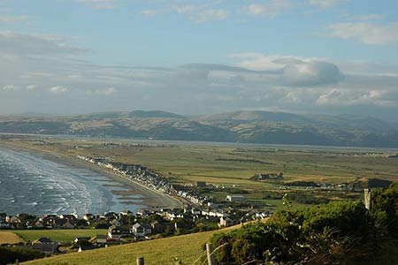
Click image to visit gallery of 3 images.
This coastal walk offers impressive views over Cardigan Bay with Snowdonia (Eryri) and the Llyn Peninsula in the north, and across Cardigan Bay to Pembrokeshire to the south. There are two steep sections of ascent although generally the going is straightforward with very easy navigation. Taking between 3 and 4 hours this walk along the Ceredigion Coast offers the chance to see Choughs with their characteristic red bill and legs. Also look out for dolphins and porpoises which can sometimes be spotted along here. A word of caution - do keep in mind that this is a typical coast path, with the sea constantly claiming more of the land, so please stick to the path, which is not suitable for those suffering from vertigo.
There is a regular bus and train service from Aberystwyth to the start of the walk in Borth (Grid ref. SN608900). From here, walk south along the seafront to the RNLI lifeboat station. Following the road and then the footpath continue uphill towards the war memorial. From the war memorial you will have the best view towards the north and over Borth Bog (Cors Fochno), the Dyfi estuary, and Snowdonia. Continue past the static caravan site on your left and follow the path. After a steep climb, looking back you can see the aptly named Craig y Delyn (or harp rock).
About 2 km further on you reach Wallog, an old mansion. Here, Sarn Gynfelyn reaches out 7-8 miles into the sea; a reminder of the last ice age. If you look closely you might even be able to find some fossils on the beach. There is also a fairly well preserved lime kiln. Between Wallog and Clarach Bay the erosion is quite bad and in places the path might be close to the edge. Make sure to stay close to the fence as sometimes the new path might not be clearly established yet.
Clarach Bay is popular with tourists, and the camping sites, static caravans, and the amusement park are busy during the summer and on bank holidays and might come as a bit of a shock coming over the hill. Cross the bridge and follow the road along the beach until it swings away to the left. Turn right and follow the footpath uphill through the trees towards Constitution Hill. On Constitution Hill the original Victorian cafe unfortunately was closed down a couple of years ago, and a new Cafe/Steakhouse opened instead. The camera obscura and the cable car still survive from the time when Aberystwyth was a famous seaside resort in the late 19th century. From up here you get a good view of Aberystwyth with its castle ruin and the pier and the iron age hillfort of Pen Dinas. Descend to the seafront and continue past the pier, castle ruins to reach the Afon Rheidol estuary (Grid ref. SN579809) where this walk ends.
Maps 

| Ordnance Survey Explorer 213 | Sheet Map | 1:25k | BUY |
| Anquet OS Explorer 213 | Digital Map | 1:25k | BUY |
| Ordnance Survey Digital Map Subscription | |||
| Latest Ordnance Survey Discounts | |||
Other walks nearby
| Walk 1705 | Bont-goch Circular from near Aberystwyth | easy/mod | 4.5 miles |
| Walk 3317 | Happy Valley Circular | easy | 4.2 miles |
| Walk 1767 | Allt Wen & Wales Coast Path from Trefechan | easy/mod | 6.0 miles |
| Walk 2048 | Craig-y-Pistyll, Cambrian Mountains | moderate | 10.0 miles |
| Walk 3230 | Tarrenhendre from Abergynolwyn | easy/mod | 5.0 miles |
| Walk 1643 | Llanfihangel-y-pennant & Castell y Bere | easy/mod | 6.8 miles |
| Walk 3582 | Castell y Bere & Llanfihangel-y-pennant from Abergynolwyn | easy/mod | 5.7 miles |
| Walk 1309 | Tarren y Gesail | moderate | 8.0 miles |
| Walk 1102 | Plynlimon & Nant-y-Moch Reservoir | hard | 11.0 miles |
| Walk 1304 | Plynlimon | moderate | 5.0 miles |
Recommended Books & eBooks
The Wales Coast Path
 A single guidebook to walking the whole Wales Coast Path - 1400km (870 miles) the length of Wales from Chester to Chepstow, including Anglesey, described in 57 stages. The route passes through the Snowdonia and Pembrokeshire National Parks and many AONBs and can be linked with the Offa's Dyke Path for a complete circuit of Wales.
More information
