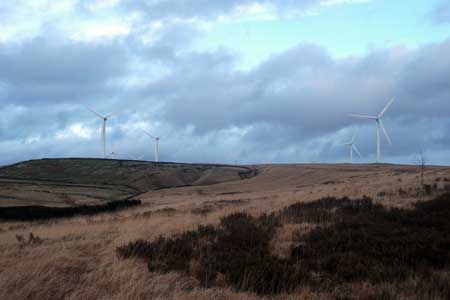
Turf Moor & Black Hill from Ashworth Resovoir
Greater Manchester Walk
County/Area - Greater Manchester & Lancashire - Rochdale
Author - Robert Owen
Length - 10.5 miles / 17.1 km Ascent - 1200 feet / 364 metres
Time - 6 hours 30 minutes Grade - moderate
Maps 

| Ordnance Survey Explorer OL21 | Sheet Map | 1:25k | BUY |
| Anquet OS Explorer OL21 | Digital Map | 1:25k | BUY |
Walk Route Description
Click image to visit gallery of 2 images.
This walk takes you up the Cheesden Moors, scaling Turf Moor initially and ending with the ascent to the trig point on Knowl Hill. Starting at the Ashworth reservoir opposite the famously haunted 'Owd Betts' public house, this is a great way to explore the new wind farm at Scout Moor whilst enjoying the solitude away from the nearby conurbations. The route also skirts around the highest point of the Forest of Rossendale - Hailstorm Hill. One feels on top of an entire City during the long descent back down the Pennine Bridleway when over the Rossendale border, whilst somehow in the total quiet of the Greater Manchester countryside. Be prepared for some breathtaking views that stretch as far as the Cheshire plain on these under-explored paths.
From Lay-by on Edenfield Road, Norden, Rochdale (A680) overlooking Ashworth Resovoir take public footpath north ascending up Ashworth Moor. When seeing junction of paths (one going to left and one to right) take left path heading in a NNW direction over Kill Gate Brook towards Cheesden Fold over a ladder stile. Keep in a NW direction walking through Cheesden Folds boggy moors and over the top of Tom Hill. Reaching a wall Tom Hill stay on footpath veering around to the right and snaking around to the left again. Head NW towards Paradise on the right and Turf Moor ahead in the distance, cross steps over Cheesden Brook (of which these pastures are named after).
Keeping on Path head W towards the stone wall which ascends up Turf Moor. When you have reached the wall follow it as it ascends north up towards an adjoining stone wall and a ladder stile. Climb over the ladder stile onto old coal road and turn right. You are now on the Rossendale Way. Keep following the old coal track NE, observing the many wind turbines on Scout Moor Wind Farm (opened in 2009). At a junction of 4WD tracks going left and right towards the Turbines, carry on straight ahead and follow the track as it swings around to the left (NW). This is probably the highest point of the walk at approx 450 metres above sea level.
Keep following track NNW towards a reservoir and the Waugh Well, enjoy the Edwin Woe memorial at Foe Edge named after this poet. Keep following track N ignoring the assorted 4WD tracks veering off the Rossendale Way. Black Hill is getting closer. Look for the clear footpath turning right and heading in a SE direction, you will notice a sign stating you are now on the Pennine Bridleway although you are still on the Rossendale Way which shares this section.
Keep following track/path ahead, still heading SE and approaching Cowpe Reservoir on your left and coming up to Cragg High Level Tank on your immediate left. Keep following the signs for the Pennine Bridleway as you contour around Top of Leach. You will eventually reach a junction on the path going two ways, left and right, with a minor track going straight ahead, take the right turn on the Pennine Bridleway heading SE as you ascend slightly up the 4WD track.
Keeping to this track you will start to descend down Hamer Hill. Keep to this clear bridleway, enjoying the splendid view across Greater Manchester with Rochdale town centre on your immediate left, Manchester City centre on the far right and views which stretch towards the Cheshire plain. Keep ahead on this clear path passing some stone ruins and ignoring a minor track that goes off to the right. Continue for approx 1.5 miles on bridleway until the first clear 4WD track appears on your right, take this path.
Continue straight ahead at the two junctions, ignoring the track that ascends Warm Slack Hill on the right. If in doubt keep heading towards the reservoirs ahead. Enter the gate for the Naden reservoirs and keep following 4WD track ahead. Follow track as it bends around to the left and goes between the middle and lower reservoir, follow path to gate ahead W of the reservoirs. Go through gate and turn left, take the higher path of the two paths, following yellow markers uphill indicating you are now on course for the Rochdale Way. Ascend this path and climb up to the top of this hill. When you have found the clear marked path for the Rochdale way, turn right heading for the nearest wind turbine and weather mast, following the markers which indicate you are on the Rochdale way, follow this path NW. Pass the weather mast and wind turbine on your right, and keep climbing up Knowl Moor. Cross over Fordoe brook towards Knowl Hill in a W direction. Ascend Knowl Hill on track reaching the trig point and old well. Enjoy the panoramic views as you sit on top of the City's conurbation. Continue on track, descending the hill and taking care on the usually boggy ground. Cross over the Red Lumb Brook. Keep following the track towards Ashworth reservoir, clearly visible as you continue descending down Ashworth Moor. You will soon be back at the start.
Note It has been reported that moto-cross bikes have cut up the path in places on this walk making progress difficult.
Other walks nearby
| Walk 3691 | Scout Moor from Ashworth Moor Reservoir | easy/mod | 4.5 miles |
| Walk 1619 | Cheeseden Brook & Pooley Bridge from Heywood | easy/mod | 7.4 miles |
| Walk 2183 | Irwell Sculpture Trail | easy | 4.5 miles |
| Walk 1458 | The Rossendale Way from Greave | easy/mod | 7.0 miles |
| Walk 2584 | Turton & Entwistle and Wayoh Resrs. from Jumbles | moderate | 10.0 miles |
| Walk 3380 | Blackstone Edge from Hollingworth Lake | moderate | 9.0 miles |
| Walk 2564 | Calf Hey, Ogden & Holden Wood Reservoirs | moderate | 7.5 miles |
| Walk 2624 | Tor Hill & High Moss, Nr Haslingden | moderate | 7.0 miles |
| Walk 1747 | Oswaldtwistle Moor | easy/mod | 6.0 miles |
| Walk 3719 | Ramsden Wood & Hades Hill from Walsden | easy/mod | 6.1 miles |
Recommended Books & eBooks
No suggestions for this area.Messaging & Social Media
Message Walking Britain and follow the latest news.

Mountain Weather
Stay safe on the mountains with detailed weather forecasts - for iOS devices or for Android devices.