Walk 1435 - printer friendly version
Sychnant Pass, Alltwen, Penmaen-Bach, & Conwy Mountain Walk
Author - Alwyn Williams
Length - 3.0 miles / 4.9 km
Ascent - 900 feet / 273 metres
Grade - easy/mod
Start - OS grid reference SH749769
Lat 53.274281 + Long -3.8775036
Postcode LL34 6TB (approx. location only)
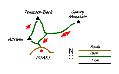
The Snowdonia (Eryri) walk starts from the lay by on the Sychnant Pass at Grid Ref SH749769. From the western end of the lay by follow the single track lane uphill for approx 150 meters. When the lane turns sharp right follow the path up the steep, short climb to the summit of Alltwen SH745774.
From the summit of Alltwen, take time to savour the views. To the West you can see the coastline of Eastern Anglesey and Puffin Island. To the East you can see the Great Orme, Llandudno and Conwy. To the South you can see the gentle slopes of the Eastern Carneddau range. On a clear day you might also be able to see the distant coastline of the Isle of Man on the horizon.
Head off the summit of Alltwen in a Northerly direction following the path which will lead you towards the summit of Penmaen-Bach. The going is fairly easy here on an easy to follow path which heads past the side wall of a field at grid ref SH746776. From here the path goes slightly uphill towards a slope of scree. You can follow the path which winds its way around the top of the summit or you can do as I did and follow an easy scramble up to the summit of Penmaen-Bach SH748780.
From the summit of Penmaen-Bach follow the faint path in a Southerly direction and pass the side wall of a field SH749775. From here the path becomes quite easy to follow and within around 200m it crosses the North Wales Path. At this point turn left to follow the North Wales Path to the Summit of Conwy Mountain.SH760778.
From the Summit of Conwy Mountain there are more impressive view of the Irish Sea, Conwy and the Eastern Carneddau. Head back along the North Wales Path in a Westerly direction back towards the starting point. At grid ref SH750774 there is a little stream that needs to be forded before the path joins the access road to Pen Pyra farm. Follow this access road down hill back to the car park from where the walk started.
Messaging & Social Media
Message Walking Britain and follow the latest news.

Mountain Weather
Stay safe on the mountains with detailed weather forecasts - for iOS devices or for Android devices.