Walk 1441 - printer friendly version
Broughton Astley, Leire, Claybrooke Magna & Sharnford Walk
Author - David McMahon
Length - 11.0 miles / 17.9 km
Ascent - 300 feet / 91 metres
Grade - easy/mod
Start - OS grid reference SP526926
Lat 52.528739 + Long -1.226080
Postcode LE9 6XS (approx. location only)
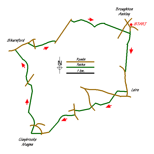
Broughton Astley is a popular village that lies south of the City of Leicester. Arriva bus service No.84 Leicester-Lutterworth runs through the village (see website for timetable). Alternatively park with consideration in the village close to the parish church (grid ref. SP526926).
The walk is started by going south down Church Close, passing the church of St Mary the Virgin, and then crossing the white-painted footbridge. Turn left immediately afterwards and follow the footpath until you meet another white-painted footbridge. Cross it and go immediately right and then left. Follow the footpath and then turn right at the junction. Go through a gate and follow the well signposted footpath until you reach the road (grid ref. SP524909).
Bear left down the road, under the rail bridge and you reach the village of Leire. Turn right into Back Lane and follow it until you see the Leicestershire Round sign. As indicated go right, ignore the footpath sign on the left, but then take the gravelly track to the left which will bring you down onto a disused railway line.
Carry on under the road bridge and climb the steps immediately afterwards to the right. Near the top of the steps you can pick up, on the left, the footpath. However it is dangerous in wet weather as there is a steep camber. Otherwise carry on into a play area and indulge yourself. Exit the play area and continue along the hedgerow and further along the field you will be able to join the footpath proper, where it is much safer.
Continue along, pass a dip in the ground and immediately afterwards a yellow sign will indicate you turn right. Cross the field and stay by the side of the hedgerow. Go over two stiles in quick succession and, keeping the hedgerow to your left, carry walking until you reach the road (grid ref. SP511895).
Pick up the footpath at the other side of the road, to the right of the wood. Go through the gap in the hedgerows to arrive at another road at a T-junction (grid ref. SP504894). Turn left and walk until you can turn right onto a bridleway. Go past the scout camp. Follow the path to the right of the wooded area where you meet once again the Leicestershire Round. Turn left through the gate. Go over the wooden bridge and carry on out of the enclosure. You will then see the village of Claybrooke Magna ahead. Aim for the left-hand side of the village.
Once you reach the road (grid ref. SP494885), continue along it until you come to a T-junction. Cross the road, go slightly to the right and pick up the footpath on the opposite side. Carry on along the enclosed footpath until it finishes and turn right at the end of the hedgerow. Climb the stile almost immediately and follow the path until you reach a road with the Pig in Muck public house on the opposite side (grid ref. SP489888). Go to the left of the pub following the road until it becomes a footpath. Continue on this path in a NNE direction until you are almost at Claybrooke Lodge Farm when the path goes diagonally to the left to join up with its driveway. Continue along the driveway until you reach a road and another meeting with the Leicestershire Round (grid ref. SP486904).
Cross the road and immediately climb the stile opposite. Go sharp right and cross another stile onto a farm track, followed by another stile on the opposite side of the track. Walk down the field and take the footbridge to the left. Go to the right and another stile which bring you onto another farm track. Turn left and then first right. As you walk down the path you will see, to the right, a hide where you can observe bird life on the lake.
At the end of the path you go slightly to the right, then back slightly left and head for gates. Carry on in the same direction with the hedgerow, followed by a stream to your right and you reach Sharnford. To your right you will see The Sharnford Arms. The other pub in the village, The Countryman, is further along in the direction of Coventry. Prior to the building of the M1 andM69 the village was on the main route between Leicester and Coventry. Thankfully things are a lot quieter nowadays.
To continue, walk past the Sharnford Arms, followed by the village church of St Helen's and carry on out of the village until you reach a sharp bend in the road. Take footpath to the right (grid ref. SP487920). The path leads to another road (grid ref. SP489919). Go left and take the footpath almost immediately opposite. Follow the path through several fields, one of which it is recommended you walk in the cultivated area, eventually you will see a yellow post in the hedgerow to the right. When it is suitable head for the post and cross the stile to find yourself on the Roman Road (grid ref. SP497921).
Turn left along the road and walk for a distance of about one kilometre. Just short of Stoney Bridge turn right onto a farm track. Walk along this track and immediately after a bridge turn left. Go diagonally right across the field to a well-concealed stile. Once over the stile go diagonally to the left and then follow the hedgerow. Ignore the first footpath on the left, but turn right after the second field boundary. Walk along the hedgerow through four field boundaries and after the last go diagonally to the right. Make your way across the field and when you are on the far headland you will see the buildings of Glebe Farm. Walk to the farm, go to the left of it, make your way through the farmyard and walk down the driveway.
When you reach the road (grid ref. SP523925), go straight across into the field opposite and carry on in the same direction. Thread your way through some shrubbery and you will find yourself coming out by the second of the white painted bridges. Retrace your steps back to the start.
Messaging & Social Media
Message Walking Britain and follow the latest news.

Mountain Weather
Stay safe on the mountains with detailed weather forecasts - for iOS devices or for Android devices.