Walk 1452 - printer friendly version
Leaholm Moor & Scaling Dam Walk
Author - Andy Chaplin
Length - 9.8 miles / 15.8 km
Ascent - 800 feet / 242 metres
Grade - moderate
Start - OS grid reference NZ756128
Lat 54.50488934 + Long -0.834020664
Postcode TS13 4TT (approx. location only)
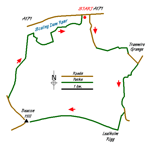
This North York Moors walk covers the moorland between Scaling Reservoir and the Esk Valley. It gives good views southwards into the Esk Valley and northwards towards the coast. The start is the Northumbrian Water public car park (grid ref. NZ756128). After parking walk east along the A171. Turn right down the road that goes south to High Tranmire Farm. Continue along the track on the southern side of the farm. Then at the gate past the farm continue straight ahead and down to the stream at the bottom of the field. Cross the stream and turn right across the field, then up to the left where it narrows towards an exit from the field into Tranmire Grange (grid ref. NZ770117). Continue south of the Grange and pick up the short, gated road towards the public road that goes south to Low Whims, High Whims and then Redmire Farm.
A track behind Redmire Farm is signposted uphill and after a dog leg it comes to a gate where you turn left towards Fern Farm on a green lane that gets better defined as you continue along it. Come down to the road through Green Houses then take the sign-posted path up the hill towards Lealholm Rigg. The path gets less well defined as you continue up hill, but aim for the highest point and you will not go far wrong - and eventually meet the track that goes between Stonegate and Beacon Hill.
It is a long, gradual walk uphill to Beacon Hill. However there are good views across the Esk valley to Great and Little Fryup Dales to compensate for the effort. At Beacon Hill (grid ref. NZ736093) there is an orientation table and a signpost that seems to indicate that the track you have walked up is actually suitable for all traffic! 4x4's maybe?
Take the road northwest to the parking place which used to be the entrance into Beacon Hill radar station where a plaque marks the place where the 1st German plane was shot down by Group Captain Peter Townsend who was also renowned for his romance with Princess Margaret. You may be able to pick up the bridleway at this point, but it is not readily visible and carrying on along the road for another 0.25 mile takes you to the point where a path leads off (grid ref. NZ729100) back towards Scaling Reservoir.
The path is well defined to a point where there is a mini-quarry then it starts to disappear as you go over the highest point of Nean Howe Rigg. Clay Hall Farm remains visible all the way so if you lose the path then keep aiming at the farm until you come to Quarry Road (grid ref NX736122) - which is really just the fence boundary between the moorland and the farmland. Go east until you pick up the paths around the reservoir and the nature reserve that you have to skirt. The paths are not great but there are information boards about the wildlife around the reservoir and nature reserve.
Once back at the car park you may even have the benefit of a mobile tea van during popular visitor times.
Messaging & Social Media
Message Walking Britain and follow the latest news.

Mountain Weather
Stay safe on the mountains with detailed weather forecasts - for iOS devices or for Android devices.