Walk 1454 - printer friendly version
Glyder Fawr & Glyder Fach from Pen-y-Pass Walk
Author - Alwyn Williams
Length - 5.5 miles / 8.9 km
Ascent - 2650 feet / 803 metres
Grade - mod/hard
Start - OS grid reference SH647555
Lat 53.079533 + Long -4.0213041
Postcode LL55 4NU (approx. location only)
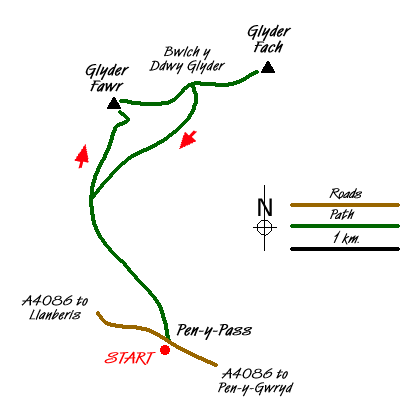
This Snowdonia (Eryri) walk takes place over remote and sometimes pathless terrain. Good map reading and navigational skills are essential on parts of this walk. This walk starts from the car park (Grid ref. SH647555) at Pen-y-Pass on the A4086 between Llanberis and Pen-y-Gwryd. The car park fills up early so arrival before 9 a.m. is essential. There is a Park and Ride service operating from Nant Peris if the car park is full.
Go left out of the car park and cross the A4086 road. Go through the gate to the left of the Pen-y-Pass Youth Hostel and follow the short path through the hostel's garden to a kissing gate. Continue along the path which gradually climbs uphill towards Llyn Cwmffynnon. Once the ground levels off, continue in a north-westerly direction towards an old sheepfold. Continue on, keeping the sheepfold to your right (Grid ref. SH646560) and head towards a small waterfall (Grid ref. SH643563). Keep the waterfall to your left and climb steeply uphill towards the crags and loose rocks at grid ref SH640565. Looking backwards you should now have an excellent view of Snowdon, Grib Goch and the Clogwyn y Person Arrête. Continue upwards until the path reappears and follow the path towards the summit of Glyder Fawr (Grid ref. SH643579).
From the summit of Glyder Fawr follow the obvious path which is marked with stone cairns in a easterly direction. Keeping the cliffs to your left continue in an easterly direction towards Bwlch y Ddwy Glyder. You will now have good views of the Ogwen Valley towards Bethesda. Pen yr Ole Wen and the High Carneddau are to the left, and Moel Siabod and the Moelwyns to the right. At Bwlch y Ddwy Glyder the path forks. Take the fork to the right dropping down for a short distance until you reach the cliffs directly in front of Castell y Gwynt (Castle of the Winds). From here an excellent view of the summit of Tryfan can be seen.
From this point the path continues in an easterly direction over the large boulders, which are a feature of this area. Continue over the boulders until you reach the summit of Glyder Fach (Grid ref. SH656583). At the summit of Glyder Fach turn back and retrace your steps back towards Bwlch y Ddwu Glyder. Reaching the Bwlch, the path forks in three directions. Take the lowest fork which goes downhill below the screes of Waun Gron and follow this path downhill back in the direction of Pen-y-pass. At grid ref. SH647576 stay to the right of the boggy ground and continue on towards where you join the path you used on the ascent to Glyder Fawr at grid ref. SH641573. Bear left and continue down this path along the crags and then look out for the small waterfall which you ascended by and continue on down to the Pen-y-Pass Youth Hostel.
Messaging & Social Media
Message Walking Britain and follow the latest news.

Mountain Weather
Stay safe on the mountains with detailed weather forecasts - for iOS devices or for Android devices.