Walk 1505 - printer friendly version
Craigellachie National Nature Reserve Walk
Author - Peter Smyly
Length - 5.0 miles / 8.1 km
Ascent - 1100 feet / 333 metres
Grade - easy/mod
Start - OS grid reference NH895123
Lat 57.188144 + Long -3.8299412
Postcode PH22 1PD (approx. location only)
This is a walk that can be completed in a couple of hours or less and one which offers a fine view over the town of Aviemore and the mountains of the Cairngorms in the distance. For anybody staying in Aviemore with a couple of hours to spare, and looking for a shorter walk to occupy part of a day, this is a good choice under the right weather conditions as, with minimal effort, there are fine views from the top ridge.
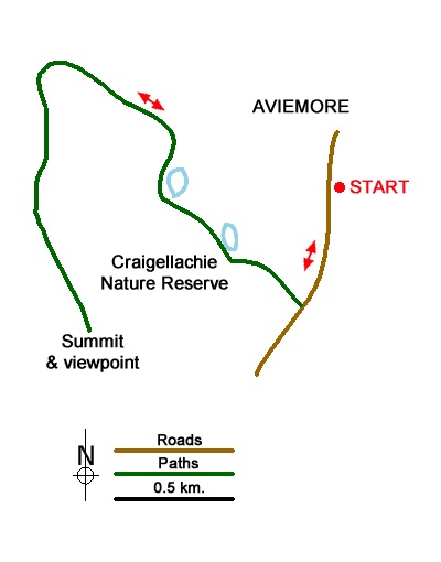
From Aviewmore Railway station (grid ref.NH895123) walk south along the main street. A sign for a catholic church off the main road passing through Aviemore leads not only to the church but Aviemore Youth Hostel. Follow the trail through woods to the right of Aviemore Youth Hostel. The path passes through a tunnel under the busy A9 and, on emerging on the other side, turns right. A noticeboard appears on the left of the path with a map of the route ahead through the woods which has silver birch trees covered in lichen, among other types of trees. A small sheet of water, Loch Puladdern, appears through the trees on the right, a shallow lake that is situated within yards of the traffic noise of the A9. It has one distinctive feature, a peninsula with a hill on it but much of the opposite end is becoming overgrown with reeds. The path skirts along the side of the hill to the left to avoid the cliffs above, but once clear of these, starts gaining height in earnest as it goes up the hill to the left with the hill of Creag nan Gabhar appearing to the right. Prior to that, the path even seems to be going the wrong way at one point as it veers off to the right for a while.
Looking back from the ascent through woodland, some of the mountains of the Cairngorms appear in the distance. There are no difficulties in route finding although the path is steep in places as it makes its way up through trees and emerges on to open felllside with a fine view of Aviemore below. The clear path leads all the way to the summit which, in July 2010, had a summit cairn, the top part of which looked precarious and about to topple over. Three lochs or lochans can be seen from the top, each one further away than the other in a row with Lochan Dubh being the one immediately below. As there is no clear way of making this walk a circular route, return to the start of the walk by reversing the outgoing route.
Messaging & Social Media
Message Walking Britain and follow the latest news.

Mountain Weather
Stay safe on the mountains with detailed weather forecasts - for iOS devices or for Android devices.