Walk 1541 - printer friendly version
Redmire, Stanage & Ughill Moor circular Walk
Author - Andy Chaplin
Length - 13.0 miles / 21.1 km
Ascent - 1620 feet / 491 metres
Grade - moderate
Start - OS grid reference SK257857
Lat 53.367547 + Long -1.6152349
Postcode S10 4QZ (approx. location only)
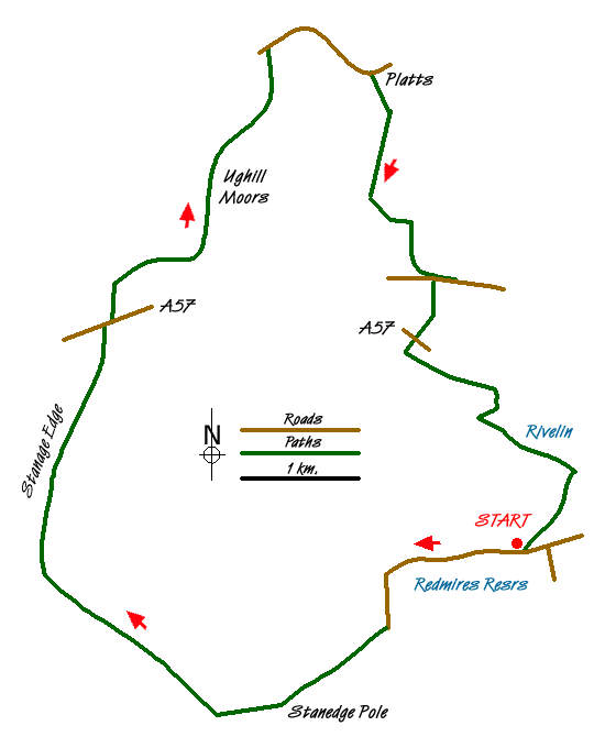
This 13 mile Peak District walk demonstrates the variation in countryside that makes Sheffield such a pleasant place from which to walk. It includes the reservoirs of Redmires and Rivelin, the views from Stanage edge, Ughill moor above the Strines and Dale Dyke reservoirs and the steep but pretty valley of the Wyming Brook.
From Sheffield Parks & Countryside parking on Redmires Road (grid ref. SK257857) walk along the road then north on the track to Stanedge pole. At the pole turn right along Stanage Edge and continue all the way to the A57 by the Sheffield Country Walk. There are fine views westwards from the edge into Derbyshire.
Cross the A57 and continue on the SCW down the road past Moscar Lodge and then turn right on the green lane behind Moscar Cross Farm - still Heathy Lane - then turn left up the Stake Hill Road track over Ughill Moor to Wet Shaw Lane. The views northwards are now across the Dale Dike valley.
Turn right on the road then after half a mile turn off right on the farm track (footpath 86) on Platts Lane past Platts Farm and on to Crawshaw Farm. Before the farm turn left across the field (footpath 85 signed to Stanedge Pole) and after the gate at the top follow Platts Lane again to the right and then over the hill to Crawshaw Lodge. Cross the road (Rod Side), turning right then off on the path to the left, and continue past Surrey Farm then over the A57 again.
Go across the field and into the wood. Turn left before the bridge on the path through the wood with the river on the right. At the stone bridge climb up from the river, cross the bridge and follow the lane - Wyming Brook Drive off to your right.
Follow the lane for three quarters of a mile until it divides then take the left fork which descends gently with views of Rivelin Upper Dam on the left. As you get to the point where the lane levels out turn right through a metal kissing gate into Wyming Brook nature area - marked with an information board.
Climb up the path through the woods alongside the Wyming Brook. There are several bridges crossing the brook and the path climbs for half a mile up the rocks at the side of the brook before levelling out at the top where there are signposted routes back to the road or Wyming Brook car parking.
At Redmires Road turn right and walk back along the road for just under a mile to the car park.
Messaging & Social Media
Message Walking Britain and follow the latest news.

Mountain Weather
Stay safe on the mountains with detailed weather forecasts - for iOS devices or for Android devices.