Walk 1553 - printer friendly version
Hannah's Meadow, Baldersdale & Brown Rigg Moss Walk
Author - Lou Johnson
Length - 8.0 miles / 13 km
Ascent - 1000 feet / 303 metres
Grade - easy/mod
Start - OS grid reference NY929186
Lat 54.56258 + Long -2.1113112
Postcode DL12 9UX (approx. location only)
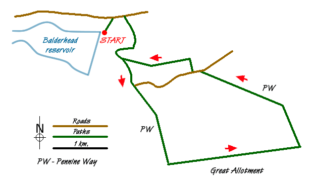
This walk explores the surroundings made famous by the lone farmer Hannah Hawkswell who used traditional methods to earn her living. The route uses sections of the Pennine Way, which in this immediate area offers two routes. It is wise to choose a clear day to fully enjoy the North Pennines' remarkable skies and landscapes.
The start is the car park at Balderhead Reservoir (grid ref. NY929186). Exit the car park and return to the road and walk west towards the High Birk Hatt, Hannah's Meadow gate (grid ref.NY933189). Turn right off the road and follow the Pennine Way north. The path takes you through Hannah's Meadow Nature Reserve and down to the shores of Blackton Reservoir. Cross Blackton Bridge and continue to the junction where the two Pennine Way routes diverge (grid ref. NY933181). Take the right fork and continue past Clove Lodge to reach a minor road, which is followed for a short way.
Turn right off the minor road following the Pennine Way signage and continue across Cotherstone Moor to reach a stile at Race Yate (grid ref. NY942160). Once across the stile turn east along a marked path for approximately 1.5 miles across the Great Allotment. Like many paths in this area, the going can be rather wet underfoot if there has been plenty of rain! This section of the route offers a true taste of the area with little sign of life apart from wildlife and sheep.
Reaching the Pennine Way at Ladywood Rigg (grid ref.NY968163), turn left. The onward route is generally well trodden and easy to follow soon reaching the minor road passed on the outward section of the walk (grid ref. NY948178). Pick up the path a few metres east and head north to east Friar House where the Pennine Way turns almost due east. The path leads you to the junction where the two Pennine Way routes meet and all you ned to do is retrace your steps back to the start.
Messaging & Social Media
Message Walking Britain and follow the latest news.

Mountain Weather
Stay safe on the mountains with detailed weather forecasts - for iOS devices or for Android devices.