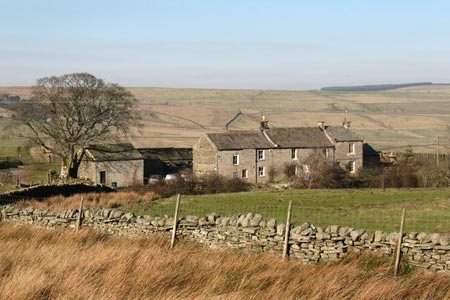
Hannah's Meadow, Baldersdale & Brown Rigg Moss
North Pennines Walk
Region - North Pennines
County/Area - Durham
Author - Lou Johnson
Length - 8.0 miles / 13 km Ascent - 1000 feet / 303 metres
Time - 5 hours 0 minutes Grade - easy/mod
Walk Route Description
Click image to see photo description.
This walk explores the surroundings made famous by the lone farmer Hannah Hawkswell who used traditional methods to earn her living. The route uses sections of the Pennine Way, which in this immediate area offers two routes. It is wise to choose a clear day to fully enjoy the North Pennines' remarkable skies and landscapes.
The start is the car park at Balderhead Reservoir (grid ref. NY929186). Exit the car park and return to the road and walk west towards the High Birk Hatt, Hannah's Meadow gate (grid ref.NY933189). Turn right off the road and follow the Pennine Way north. The path takes you through Hannah's Meadow Nature Reserve and down to the shores of Blackton Reservoir. Cross Blackton Bridge and continue to the junction where the two Pennine Way routes diverge (grid ref. NY933181). Take the right fork and continue past Clove Lodge to reach a minor road, which is followed for a short way.
Turn right off the minor road following the Pennine Way signage and continue across Cotherstone Moor to reach a stile at Race Yate (grid ref. NY942160). Once across the stile turn east along a marked path for approximately 1.5 miles across the Great Allotment. Like many paths in this area, the going can be rather wet underfoot if there has been plenty of rain! This section of the route offers a true taste of the area with little sign of life apart from wildlife and sheep.
Reaching the Pennine Way at Ladywood Rigg (grid ref.NY968163), turn left. The onward route is generally well trodden and easy to follow soon reaching the minor road passed on the outward section of the walk (grid ref. NY948178). Pick up the path a few metres east and head north to east Friar House where the Pennine Way turns almost due east. The path leads you to the junction where the two Pennine Way routes meet and all you ned to do is retrace your steps back to the start.
Maps 

| Ordnance Survey Explorer OL31 | Sheet Map | 1:25k | BUY |
| Anquet OS Explorer OL31 | Digital Map | 1:25k | BUY |
| Ordnance Survey Digital Map Subscription | |||
| Latest Ordnance Survey Discounts | |||
Other walks nearby
| Walk 2228 | Romaldkirk Moor | easy/mod | 7.6 miles |
| Walk 1005 | Harter Fell & Grassholme | moderate | 8.0 miles |
| Walk 1482 | Crossthwaite Common from Middleton-in-Teesdale | moderate | 9.8 miles |
| Walk 1483 | Eggleston & Romaldkirk from Middleton-in-Teesdale | easy/mod | 9.8 miles |
| Walk 1484 | Kirkcarrion from Middleton-in-Teesdale | easy | 3.5 miles |
| Walk 1485 | Hamsterley & Middleton-in-Teesdale | mod/hard | 16.5 miles |
| Walk 1488 | Middleton-in-Teesdale Railway Walk | easy | 2.5 miles |
| Walk 2258 | Grassholme Reservoir from Middleton-in-Teesdale | moderate | 8.2 miles |
| Walk 2157 | Romaldkirk & Cotherstone | easy | 5.0 miles |
| Walk 2170 | Eggleston & Mickleton from Romaldkirk | easy/mod | 5.8 miles |
Recommended Books & eBooks
The Pennine Way
 Guidebook to the Pennine Way National Trail with OS map booklet. The 265 mile route from Edale to Kirk Yetholm takes three weeks to walk and is suitable for fit and experienced long distance walkers. The route crosses the Peak District, Yorkshire Dales and North Pennines National Parks. Includes separate OS 1:25,000 map booklet of the route.
More information
The Pennine Way - the Path, the People, the Journey
 A portrait of the The Pennine Way, Britain's oldest and best known long-distance footpath, stretching 268 miles from the Peak District to the Scottish Borders. This personal, thoughtful and often humorous story of the path's remarkable history, includes the experiences of walkers and local characters on this exhilarating and complex path.
More information
