Walk 1564 - printer friendly version
Hayburn Wyke from Scalby Walk
Author - Andy Chaplin
Length - 10.2 miles / 16.6 km
Ascent - 750 feet / 227 metres
Grade - moderate
Start - OS grid reference TA018909
Lat 54.30357 + Long -0.43705928
Postcode YO13 0QG (approx. location only)
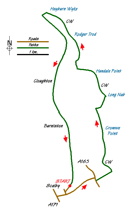
This North York Moors walk is another circular route based on the Cleveland Way. As with a lot of the southern section of the CW it is possible to come back via the old coastal railway. Unlike some of the sections, the railway here follows a route that does not go through many cuttings and is pleasantly open to walk along offering wide views. As with all coastal and railway walks it is easy to follow. If you can still see the sea and your feet aren't wet then you are probably following the path. On the way back, if you can hear the crunch of railway ballast under your feet then the same applies.
There are 4 parking spaces at the end of the railway path on Lancaster Way in Scalby (Grid ref. TA018909) and more on the road between house drives. Remember to park with courtesy. Walk down Lancaster Way, go left on Field Close Lane, left on Station Road then take Field Lane to the A165. Cross this main road and turn right down to the path that goes to the coast.
Reaching the coast, head north on the Cleveland Way, with the sea to your right. Follow the CW markers past Cromer Point and Crook Ness to Long Nab where there is the old Coastguard station that is now used as a bird watching point. There are great views up the coast and back towards Scarborough, the Castle and Oliver's Mount
After the viewpoint at Roger Trod the path goes slightly inland behind a wood before continuing along the coast to Hayburn Wyke. When the path reaches the first National Trust sign for Hayburn Wyke, leave the CW and go left, down through a gate and across the field heading right towards the track that leads to the Hayburn Wyke Inn. When you meet the road it is a short distance on the right to the Inn or a similar distance on the left to the old railway track which crosses the road on the bend.
Take the railway track southwards. This initially follows the Newlands Dale valley below the CW path so there is no view of the sea but the walk is pleasantly open and easy walking. At Burniston the path crosses the road as the bridge has been removed. The route ahead is slightly offset on your left when you cross the road. Then continue on back to the parking on Lancaster Way.
Messaging & Social Media
Message Walking Britain and follow the latest news.

Mountain Weather
Stay safe on the mountains with detailed weather forecasts - for iOS devices or for Android devices.