Rydal Water & Grasmere circular
Lake District Walk
Nat Park - Lake District - Lake District Central Fells
County/Area - Cumbria
Author - Lou Johnson
Length - 6.0 miles / 9.8 km Ascent - 1200 feet / 364 metres
Time - 4 hours 10 minutes Grade - easy/mod
Maps 

| Ordnance Survey Explorer OL7 | Sheet Map | 1:25k | BUY |
| Anquet OS Explorer OL7 | Digital Map | 1:25k | BUY |
| Ordnance Survey Landranger 90 | Sheet Map | 1:50k | BUY |
| Anquet OS Landranger 90 | Digital Map | 1:50k | BUY |
Walk Route Description
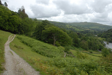
Click image to visit gallery of 6 images.
The Lake District has a wide variety of low level walks. Sadly many walkers reserve these for days when the clouds lie low over the higher fells meaning that they never enjoy them at their best. This walk starts from the regional centre of Grasmere and follows a well walked track to Rydal. From here the route passes the shores of Rydal water before enjoying wide ranging views over Grasmere. As well as the scenic interest the walk passes two of the homes of William Wordsworth, namely Dove Cottage and Rydal Mount. Both of these are passed by the walk and can be visited with an admission fee.
The start is the large pay and display car park (grid ref. NY339072) just off the A591 Ambleside to Keswick Road. Exit the car park and turn left back to the main road. Cross the A591, and take the lane opposite passing Dove Cottage on your left. Walk along the lane until just before it bends right. Here leave the lane and continue ahead on a stony track. At first the track goes uphill but soon levels off to follow a more undulating course across the fellside all the way to Rydal. Reaching Rydal, turn right down past the church to the main road.
Cross the main road and turn left walking towards Ambleside. At the first road junction, turn right and cross the bridge. Once on the other side of the River Rothay turn right again along a tarmac lane. Continue past some cottages after which the lane becomes a rougher track and exits onto open pastures. The path forks (grid ref. NY358060). Bear left here to join the higher path which leads past caves and old quarries. At the next major junction (grid ref. NY347059) continue along the Loughrigg Terrace path which offers a fine view of Grasmere and the superb backdrop of higher fells.
Just before reaching a plantation of trees turn right and descend very steeply to the shore of Grasmere. Turn left and follow the lakeside path as far as you can (grid ref. NY335064). Here turn away from the lake to reach a lane. Turn right along the lane and walk back into Grasmere village.
Other walks nearby
| Walk 3625 | Silver How from Grasmere | easy | 3.2 miles |
| Walk 1154 | Between Grasmere and Langdale | moderate | 9.5 miles |
| Walk 1111 | High Raise & Helm Crag | mod/hard | 9.5 miles |
| Walk 1823 | Fairfield Horseshoe & Loughrigg from High Close | mod/hard | 14.0 miles |
| Walk 2254 | Grisedale Tarn from Grasmere | moderate | 5.5 miles |
| Walk 2841 | Seat Sandal via Grisedale Tarn from Grasmere | moderate | 5.0 miles |
| Walk 2932 | Green Burn horseshoe from Grasmere | moderate | 7.0 miles |
| Walk 2715 | Skelwith Bridge & Loughrigg | easy/mod | 5.5 miles |
| Walk 1684 | Lingmoor Fell & Langdale | easy/mod | 7.0 miles |
| Walk 1141 | Elterwater circular | easy/mod | 4.0 miles |
Recommended Books & eBooks
Lake District: High Level and Fell Walks
 This guidebook describes 30 graded fell walks on the ridges and high peaks of the English Lake District, the UK's most popular national park. Reaching some of England's finest and highest mountain scenery, this guide leads readers to classic horseshoes and traditional ascents as well as lesser-known routes to quieter summits.
More information
Hadrian's Wall Path
 Hadrians Wall Path guidebook to walk the 84 mile National Trail. Described in both directions, the main description is west to east between Bowness-on-Solway and Wallsend, Newcastle, with extensions to Maryport and South Shields. With extensive historical information related to this World Heritage site and separate 1:25,000 OS map booklet included.
More information
Messaging & Social Media
Message Walking Britain and follow the latest news.

Mountain Weather
Stay safe on the mountains with detailed weather forecasts - for iOS devices or for Android devices.