Rydal Water & Grasmere
Lake District Walk
Nat Park - Lake District - Lake District Central Fells
County/Area - Cumbria
Author - Lou Johnson
Length - 5.5 miles / 8.9 km Ascent - 700 feet / 212 metres
Time - 3 hours 30 minutes Grade - easy/mod
Walk Route Description
Click image to see photo description.
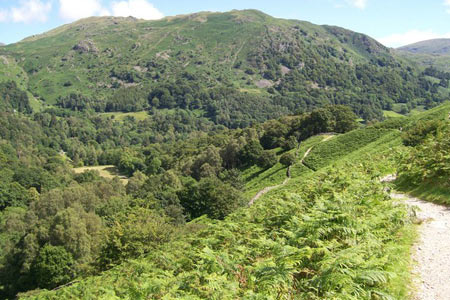
The Lake District has a wide variety of low level walks which are often reserved for the days when clouds lie low over the fells. However, this walk is probably best completed in fine weather as the views are superb. The walk starts from the regional centre of Grasmere and follows a well walked track to Rydal. From here the route passes the shores of Rydal Water before enjoying wide ranging views over Grasmere. As well as the scenic interest the walk passes two of the homes of William Wordsworth, namely Dove Cottage and Rydal Mount. Both of these are passed during the walk and can be visited on payment of an admission fee. This walk is similar to Walk 1565 but includes an alternative return into Grasmere village.
The start is the large pay and display car park (grid ref. NY339072) just off the A591 Ambleside to Keswick Road. Exit the car park and turn left back to the main road. Cross the A591, and take the lane opposite passing Dove Cottage on your left. Walk along the lane until just before it bends right. Here leave the lane and continue ahead on a stony track. At first the track goes uphill but soon levels off to follow a more undulating course across the fellside all the way to Rydal. Reaching Rydal, turn right past the church to the main road.
Cross the main road and turn right walking towards Grasmere. Take the signed path on your left and cross the bridge over the River Rothay. Once across the bridge take the path on your right. This leads through woodland to the shores of Rydal Water with Nab Scar providing a scenic backdrop. The path soon leaves the shores of the lake and climbs gently to reach a path junction (grid ref. NY347060). Here ignore the path leading down to the shores of Grasmere instead taking the clear path across the fellside. This is Loughrigg Terrace and offers fine views over Grasmere on your right.
Reaching an area of woodland at the end of the Terrace path, ignore the path descending through the trees on your right and continue straight ahead to reach a lane - Red Bank (grid ref. NY340056). Turn right down Red Bank and take the first signed footpath on your left. This leads through Red Bank Wood to join a walled track. Bear right down this track to the road near the Wyke. Turn left along this road and follow into the centre of Grasmere. Reaching a junction, turn right in front of the church and you will find the car park a short way on your left.
Maps 

| Ordnance Survey Explorer OL7 | Sheet Map | 1:25k | BUY |
| Anquet OS Explorer OL7 | Digital Map | 1:25k | BUY |
| Ordnance Survey Digital Map Subscription | |||
| Latest Ordnance Survey Discounts | |||
Other walks nearby
| Walk 3625 | Silver How from Grasmere | easy | 3.2 miles |
| Walk 1154 | Between Grasmere and Langdale | moderate | 9.5 miles |
| Walk 1111 | High Raise & Helm Crag | mod/hard | 9.5 miles |
| Walk 1823 | Fairfield Horseshoe & Loughrigg from High Close | mod/hard | 14.0 miles |
| Walk 2254 | Grisedale Tarn | moderate | 5.5 miles |
| Walk 2841 | Seat Sandal via Grisedale Tarn from Grasmere | moderate | 5.0 miles |
| Walk 2932 | Green Burn horseshoe from Grasmere | moderate | 7.0 miles |
| Walk 2715 | Skelwith Bridge & Loughrigg | easy/mod | 5.5 miles |
| Walk 1684 | Lingmoor Fell & Langdale | easy/mod | 7.0 miles |
| Walk 1141 | Elterwater circular | easy/mod | 4.0 miles |
Recommended Books & eBooks
Great Mountain Days in the Lake District
 An inspirational guidebook to 50 challenging walks on the high fells of the Lake District. The graded circular routes, between 4 and 14 miles in length, cover classic Lakeland summits like Fairfield, Scafell Pike, Great Gable and Blencathra, to the lesser-known High Spy, King's How and Brund Fell.
More information
Walking the Lake District Fells - Keswick
 Part of the Walking the Lake District Fells series, this guidebook covers a wide range of routes to 30 Lakeland summits that can be climbed from Keswick, Whinlatter, Bassenthwaite, Caldbeck, Mungrisdale and Threlkeld, with highlights including Skiddaw and Blencathra. Includes suggestions for longer ridge routes.
More information
