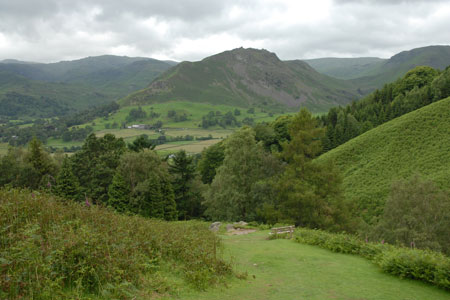
Alcock Tarn & Rydal Water from Grasmere
Lake District Walk
Nat Park - Lake District - Lake District Central Fells
County/Area - Cumbria
Author - Lou Johnson
Length - 7.0 miles / 11.4 km Ascent - 1600 feet / 485 metres
Time - 5 hours 10 minutes Grade - easy/mod
Walk Route Description
Click image to visit gallery of 9 images.
This Lake District circular walk starts from the village of Grasmere and begins by climbing onto the fells to visit Alcock Tarn. The route continues into the Rydal and returns via Rydal water and Grasmere. The views throughout are excellent so choose a fine day. There is one section of sustained ascent towards the beginning of the route although this is over a well-maintained path.
The start is the large pay and display car park (grid ref. NY339072) at the southern end of the village near the A591 Keswick to Ambleside road. Exit the car park and turn right to walk through the village following the B5287 to reach the A591 at the northern end of the village (grid ref. NY339082). Cross the main road and take the lane to the right of the Swan Hotel. Continue along this lane continuing straight ahead at the first junction. Turn right at grid ref. NY340083 and follow the signed footpath for Alcock Tarn. The path crosses a river and then starts a steep climb up the fellside. This is well maintained and offers improving views over Grasmere and the surrounding fells. Alcock Tarn is soon reached and provides an excellent place to take a break. From here the emphasis of the view changes with the panorama now including Windermere and other salient features in the southern Lake District.
Continuing, start the descent towards Rydal. Follow the clear path as it drops across the fellside passing a small lake. Eventually this leads down to a track (grid ref. NY344072). Turn left and follow the track to reach a lane (grid ref NY344067). Turn left and follow this track to follow an undulating course across the fellside all the way to Rydal. Reaching Rydal, turn right past the church down to the main road.
Cross the main road and turn left walking towards Ambleside. At the first road junction, turn right and cross the bridge. Once on the other side of the River Rothay turn right again along a tarmac lane. Continue past some cottages after which the lane becomes a rougher track and exits onto open fellside. The path forks (grid ref. NY358060). Bear right here to join the lower path which initially follows the shore of Rydal Water. At the next junction (grid ref. NY347059) bear slightly right to descend to a footbridge (grid ref. NY343059). Cross the bridge and bear left on the other side now following the shore of Grasmere, which is on your left. This path leads to the A591 road. Turn left along the road and follow the pavement alongside Grasmere. Walk past the hotel and take the next left. This leads back to the start.
Maps 

| Ordnance Survey Explorer OL7 | Sheet Map | 1:25k | BUY |
| Anquet OS Explorer OL7 | Digital Map | 1:25k | BUY |
| Ordnance Survey Digital Map Subscription | |||
| Latest Ordnance Survey Discounts | |||
Other walks nearby
| Walk 3625 | Silver How from Grasmere | easy | 3.2 miles |
| Walk 1154 | Between Grasmere and Langdale | moderate | 9.5 miles |
| Walk 1111 | High Raise & Helm Crag | mod/hard | 9.5 miles |
| Walk 1823 | Fairfield Horseshoe & Loughrigg from High Close | mod/hard | 14.0 miles |
| Walk 2254 | Grisedale Tarn | moderate | 5.5 miles |
| Walk 2841 | Seat Sandal via Grisedale Tarn from Grasmere | moderate | 5.0 miles |
| Walk 2932 | Green Burn horseshoe from Grasmere | moderate | 7.0 miles |
| Walk 2715 | Skelwith Bridge & Loughrigg | easy/mod | 5.5 miles |
| Walk 1684 | Lingmoor Fell & Langdale | easy/mod | 7.0 miles |
| Walk 1141 | Elterwater circular | easy/mod | 4.0 miles |
Recommended Books & eBooks
Great Mountain Days in the Lake District
 An inspirational guidebook to 50 challenging walks on the high fells of the Lake District. The graded circular routes, between 4 and 14 miles in length, cover classic Lakeland summits like Fairfield, Scafell Pike, Great Gable and Blencathra, to the lesser-known High Spy, King's How and Brund Fell.
More information
Walking the Lake District Fells - Buttermere
 Part of the Walking the Lake District Fells series, this guidebook covers a wide range of routes to 32 Lakeland summits that can be climbed from the Buttermere, Lorton and Newlands valleys, with highlights including Haystacks, High Stile, Grasmoor and the fells of the Coledale Round. Suggestions for longer ridge routes are also included.
More information
