Walk 1575 - printer friendly version
Tophill Reservoir Walk
Author - Yorkshire Water
Length - 3.0 miles / 4.9 km
Ascent - 50 feet / 15 metres
Grade - easy
Start - OS grid reference TA073486
Lat 53.922431 + Long -0.36757357
Postcode YO25 9RH (approx. location only)
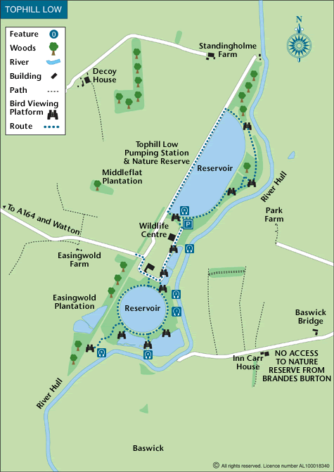
This walk in the East Riding of Yorkshire visits the two reservoirs at Tophill Low which can be reached from the A164 Beverley to Driffield road. The reservoirs form part of a Nature Reserve which is also a Site of Special Scientific Interest (SSSI). A haven for thousands of birds there are 12 hides located around the reservoir's perimeter for those who want a closer look at the wildlife. NOTE The site is open Wednesday to Sunday inclusive and you are advised to check specific times before travelling to the site. There is an information centre on site.
This is one of the free reservoir walks produced by Yorkshire Water who are one of the county's largest landowners, with around 72,000 acres of land spanning National Parks, Areas of Outstanding Natural Beauty, the North York Moors and the Yorkshire Wolds. There is a wide range of walks on offer from gentle strolls around one of their picturesque reservoirs to more adventurous routes. Yorkshire Water have selected some of their top walks for you and split them into three regional packs. Just print them out and off you go.
Each site has its own walk pack that you can easily print out and take along with you. Each pack includes directions to the site, a summary of the walk, a list of facilities available, a detailed route map and route instructions. To download walk descriptions go to Yorkshire Water Walks.
Messaging & Social Media
Message Walking Britain and follow the latest news.

Mountain Weather
Stay safe on the mountains with detailed weather forecasts - for iOS devices or for Android devices.