Tophill Reservoir
East Yorkshire Walk
County/Area - East Yorkshire
Author - Yorkshire Water
Length - 3.0 miles / 4.9 km Ascent - 50 feet / 15 metres
Time - 1 hours 30 minutes Grade - easy
Walk Route Description
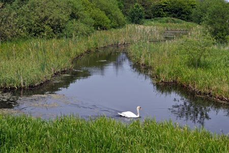
Click image to see photo description.
This walk in the East Riding of Yorkshire visits the two reservoirs at Tophill Low which can be reached from the A164 Beverley to Driffield road. The reservoirs form part of a Nature Reserve which is also a Site of Special Scientific Interest (SSSI). A haven for thousands of birds there are 12 hides located around the reservoir's perimeter for those who want a closer look at the wildlife. NOTE The site is open Wednesday to Sunday inclusive and you are advised to check specific times before travelling to the site. There is an information centre on site.
This is one of the free reservoir walks produced by Yorkshire Water who are one of the county's largest landowners, with around 72,000 acres of land spanning National Parks, Areas of Outstanding Natural Beauty, the North York Moors and the Yorkshire Wolds. There is a wide range of walks on offer from gentle strolls around one of their picturesque reservoirs to more adventurous routes. Yorkshire Water have selected some of their top walks for you and split them into three regional packs. Just print them out and off you go.
Each site has its own walk pack that you can easily print out and take along with you. Each pack includes directions to the site, a summary of the walk, a list of facilities available, a detailed route map and route instructions. To download walk descriptions go to Yorkshire Water Walks.
Maps 

| Ordnance Survey Explorer 295 | Sheet Map | 1:25k | BUY |
| Anquet OS Explorer 295 | Digital Map | 1:25k | BUY |
| Ordnance Survey Digital Map Subscription | |||
| Latest Ordnance Survey Discounts | |||
Other walks nearby
| Walk 1433 | Martin & Metheringham circular | easy | 6.3 miles |
| Walk 3428 | Boynton from Rudston Circular | easy | 6.5 miles |
| Walk 3740 | Cowlam & Cottam Circular | easy/mod | 8.0 miles |
| Walk 3349 | Pasture Dale, Frendal Dale and Horsedale from Huggate | easy/mod | 9.1 miles |
| Walk 1779 | Horse Dale, Holm Dale, Tun Dale and Frendal Dale from Huggate | easy/mod | 9.0 miles |
| Walk 2264 | Bridlington & Flamborough Head | easy/mod | 6.8 miles |
| Walk 2141 | Brantingham & Elloughton Dale | easy/mod | 5.7 miles |
| Walk 2655 | Wayram To Fridaythorpe Circular | easy/mod | 7.5 miles |
| Walk 2906 | Circular from Wayrham Through Painsthorpe | moderate | 8.5 miles |
| Walk 3127 | Bishop Wilton & Millington | moderate | 13.4 miles |
