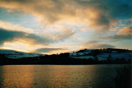
Damflask Reservoir
Peak District Walk
Nat Park - Peak District - Derwent Edge Sheffield
County/Area - South Yorkshire
Author - Yorkshire Water
Length - 3.5 miles / 5.7 km Ascent - 100 feet / 30 metres
Time - 1 hours 50 minutes Grade - easy
Walk Route Description
Click image to see photo description.
Damflask Reservoir occupies a pleasant location near the village of Low Bradfield to the north-west of Sheffield. As might be expected from a walk in the Peak District National Park, this route offers woodland and open country with wide views across the reservoir.
This is one of the free reservoir walks produced by Yorkshire Water who are one of the county's largest landowners, with around 72,000 acres of land spanning National Parks, Areas of Outstanding Natural Beauty, the North York Moors and the Yorkshire Wolds. There is a wide range of walks on offer from gentle strolls around one of their picturesque reservoirs to more adventurous routes. Yorkshire Water have selected some of their top walks for you and split them into three regional packs. Just print them out and off you go.
Each site has its own walk pack that you can easily print out and take along with you. Each pack includes directions to the site, a summary of the walk, a list of facilities available, a detailed route map and route instructions. To download walk descriptions go to Yorkshire Water Walks.
Maps 

| Ordnance Survey Explorer OL1 | Sheet Map | 1:25k | BUY |
| Anquet OS Explorer OL1 | Digital Map | 1:25k | BUY |
| Ordnance Survey Digital Map Subscription | |||
| Latest Ordnance Survey Discounts | |||
Other walks nearby
| Walk 1285 | Dungworth & Rod Moor | moderate | 9.4 miles |
| Walk 1577 | Low Bradwell & Agden Reservoir | easy | 3.5 miles |
| Walk 1754 | Agden Reservoir Circular | easy/mod | 4.8 miles |
| Walk 1578 | Dale Dike Reservoir | easy | 2.5 miles |
| Walk 2728 | Wadsley and Loxley Commons, Sheffield | easy/mod | 7.9 miles |
| Walk 3439 | High Bradfield from Glen Howe | moderate | 8.3 miles |
| Walk 2516 | Moscar, Dale Dike & Shrines Reservoirs | easy/mod | 7.0 miles |
| Walk 2629 | Stanage Edge, Redmires & Hallam Moors | easy/mod | 8.5 miles |
| Walk 2235 | Bamford & Stanage Edges | moderate | 9.9 miles |
| Walk 3330 | Rivelin Valley from Malin Bridge | easy/mod | 9.7 miles |
Recommended Books & eBooks
Dark Peak Walks
 Guidebook to 40 walks in the Dark Peak area of the Peak District National Park. 35 circular routes for most abilities, from 8km to 19km, around Edale, Marsden, Fairholmes, Baslow and Castleton, including Kinder Scout and Mam Tor, and 5 longer (25km to 45km) routes highlighting the best of the Gritstone Edges, High Moorland and Deep Valleys.
More information
Walking in the Peak District - White Peak East
 Guidebook describing 42 half-day and day walks in the limestone landscapes of Derbyshire's White Peak, part of the Peak District National Park. One of two volumes, this book covers the east of the region, with potential bases including Bakewell, Eyam, Castleton, Birchover, Matlock and Wirksworth.
More information
