Walk 1601 - printer friendly version
Bowcombe Down & Upper Watchingwell Walk
Author - Zelma Barnes
Length - 8.0 miles / 13 km
Ascent - 820 feet / 248 metres
Grade - easy/mod
Start - OS grid reference SZ486882
Lat 50.691427 + Long -1.3133264
Postcode PO30 1NR (approx. location only)
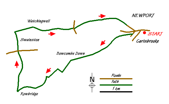
This circular walk starts from Carisbrooke and crosses Bowcombe Down to reach Ashengrove. The route continues via Swainston and Lower Watchingwell to return to the start. The walk is generally easy going but the last half can be a bit muddy after prolonged rain.
The start is the free car park in Carisbrooke High Street (Grid ref. SZ486882). Leave car park and walk up hill, go straight across at the mini roundabout and carry on up until you get to Nodgeham Lane on your left. Go into lane and after a few yards take the bridleway way on your right, marked Tennyson Trail. Follow this trail for approximately one mile.
The route takes you up the hill, across an open area and along a lane. When you come out of the lane go straight ahead along the edge of the large field, keeping to the farm track. At the end of this field enter a short lane and then continue into another field. Keep going straight ahead. Just as you reach the gate at the end of this field (Grid ref. SZ458 868), go sharp right. This usually has a couple of gates tied together and is marked as Footpath.
This path goes across the centre of a field and there is a large tree on your left towards the bottom of field. Go through the gates and keep going down where you will find a stile in the bushes on your left. Go over the stile, down through the undergrowth and over the next stile into the field. Go left here, keeping the small copse on your left. At the bottom of this field go through the gate and then turn right up the side of this small field to the stile at the top which will take you out onto Rowridge Lane.
Go left along this metalled lane until you reach the farmhouse. Walk in front of house, through a metal gate which bolts into a crevice in the wall, into a small paddock which usually has chicken and some sheep in, and through another gate into copse/lane. Be careful when walking in spring and summer as the undergrowth covers a very large ditch running down the centre of path. This has been caused by water run off and is hard to control. When you come out of this copse go ahead up the valley of the field to the signpost you can see in front of you.
At the signpost (Grid ref SZ443 859) go right along track and through the jockey gate on your left. Now go through the jockey gate on your immediate right. Go along this field keeping the fence and TV mast on your right. Go into the lane and follow this track through copse, field and farmyard until you reach the main Calbourne Road at Ashengrove Farm.
Cross the main road and go into Swainston Manor Road. Bear right at the Y junction, past a few houses on your right and derelict glasshouses on your left. After several yards of walking between trees, take the gravel lane on your right (Grid ref. SZ442 882). This gravel road takes you to Upper Watchingwell and Watchingwell Halt, the old railway station. The owners of the Halt have started to keep rare breed pigs and if you turn sharp left past their house you usually can see and talk to the pigs over the field gate just by the stables.
The actual walk goes past Watchingwell Halt and then bears right (away from pigs) to Great Park Farm where the lane turns from gravel to concrete. At the crossroads with a metalled road, go straight over. At the white farmhouse take the footpath on your right along the chalk road on the edge of the field. Be careful when you get close to the next farm as there are often electric fences across the footpath, but they all have handles for safety of opening. At the farm, go through the wooden gate and right along the metalled lane to the corner where you go over the stile in the hedge on your left.
Go along this field and into the lane and farmyard beyond. This is Alvington Farm (Grid ref. SZ475 886) and the path goes straight ahead. There is a large footpath sign on the grey barn reminding you of this fact! When you leave the farm buildings, you come on to a gravel road on the edge of a field, which then leads on to a metalled road. Go along this road (Alvington Road) to the T junction at the end where you go left down the hill. Go straight across at the mini roundabout, through the churchyard and at the bottom of the steps cross the road to the car park.
Messaging & Social Media
Message Walking Britain and follow the latest news.

Mountain Weather
Stay safe on the mountains with detailed weather forecasts - for iOS devices or for Android devices.