Walk 1602 - printer friendly version
Saltergate, Fylingdales & Allerston High Moor Walk
Author - Phil Catterall
Length - 11.5 miles / 18.7 km
Ascent - 1150 feet / 348 metres
Grade - moderate
Start - OS grid reference SE853937
Lat 54.331746 + Long -0.68974873
Postcode YO18 7NR (approx. location only)
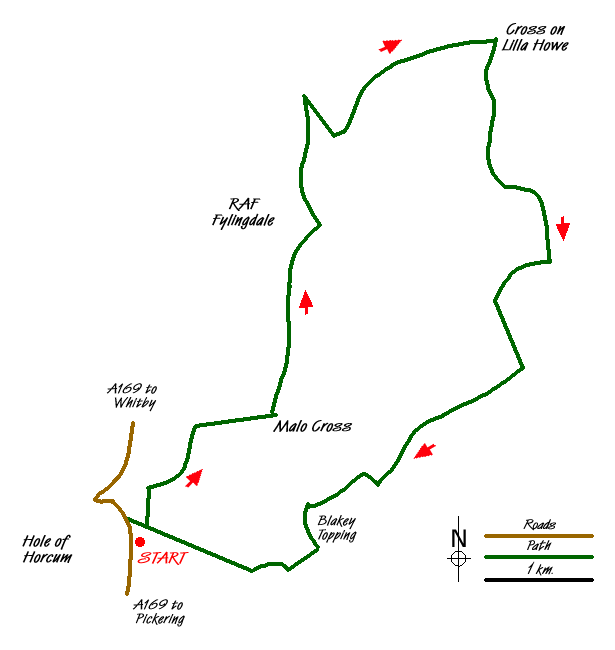
A circular walk in the North York Moors National Park explores the longest tract of heather moorland in England, taking a close look at RAF Fylingdales Early Warning Station and two historic crosses. Returning to the Hole of Horcum and Saltergate via Langdale Forest. Ample free parking is available at the Hole of Horcum Car Park (grid ref. SE853937) on the A169 Pickering to Whitby main road.
Walk north alongside the A169 from the car park for 300m, taking the waymarked track on your right, before the road drops steeply downhill. After 300m, turn left onto a Bridleway - a mobile phone mast can be seen further along this path. At the end of the strip of woodland turn right to walk along the ridge of Saltergate Brow - the A169 and the former "Legendary Saltergate Inn" can be seen across the valley (pictured). The Inn is currently being refurbished (early 2009) and is expected to reopen in due course.
At grid ref. SE859949 be careful to follow the right hand path to gradually follow the bridleway down the brow to Malo Cross (grid ref. SE866949). Do not take the steeper farmers track to the left. At Malo Cross a good view is afforded of Blakey Topping. This is an unusually flat topped summit 1 Km to the south. Above Malo Cross is the escarpment of Whinny Nab, situated at the end of Saltergate Brow. Malo Cross dates back to the 17th century, however in the 19th century the cross disappeared, allegedly turning up in a Pickering garden in 1924. It was then relocated back to its original location here.
We now pass through the gate (left) and head north from Malo Cross towards RAF Fylingdales. This section of the route can be boggy in places depending on the time of year. Our route continues alongside Eller Beck Head Wood to grid ref. SE871968 where RAF Fylingdales now allow us to use a Permissive Path. The route is well marked and passes close to the perimeter fence of the base being part path, part perimeter track. At grid ref. SE869970 near the phased array (see picture) and powerhouse, we turn right and head towards a gate at grid ref. SE870976 (also pictured). No path is indicated on the OS map.
Be aware that the landowner here has decreed that this is a conservation moor. Continue north to grid ref. SE869981 and then double back, crossing Eller Beck on a concrete bridge to head uphill to join a moorland track at grid ref. SE872977. This is an easier route than continuing to Sheepfold where the Lyke Wake Walk travels west to east. This section of the Lyke Wake Walk is badly drained. Continue on the track across Lilla Rigg to grid ref. SE886986. Lilla Cross is reached via a short path. On a fine day this makes a good lunch stop, with views to the coast. Lilla Cross is probably the finest historic monument on the North York Moors and marks the grave of Lilla who saved the life here of King Edwin of Northumbria in 625 AD. Leaving Lilla Cross we head south on a bridleway heading towards Derwent Head and Langdale Forest, turning left onto a forest track at the edge of the forest (grid ref. SE890972).
We now have a 3.5 mile walk along forest tracks. Turn right at grid ref. SE894964 and take the left fork at grid ref. SE888961. Turn right at the crossroads (grid ref. SE891954). Blakey Topping soon appears in sight and there is also a good view across to Whinny Nab that we earlier saw from Malo Cross. When you reach the track junction at grid ref. SE877942 go North West. At grid ref. SE870840 take the left fork to curve around Blakey Topping to arrive at Newgate Foot. The track takes you through some gates and into the farmyard. Keep right to follow the concrete track steeply uphill following through to reach Old Wife's Way. It's now just a straight walk back to the Hole of Horcum passing a hangar and small private airfield at grid ref. SE857937.
Messaging & Social Media
Message Walking Britain and follow the latest news.

Mountain Weather
Stay safe on the mountains with detailed weather forecasts - for iOS devices or for Android devices.