Walk 1635 - printer friendly version
Garnedd Uchaf & Llyn Eigiau Walk
Author - Mike Bexley
Length - 9.0 miles / 14.6 km
Ascent - 2100 feet / 636 metres
Grade - mod/hard
Start - OS grid reference SH731662
Lat 53.177726 + Long -3.9002186
Postcode LL32 8SH (approx. location only)
I have graded this Snowdonia (Eryri) walk in a wild remote area as moderate/hard due to the steep climbing during the first part of the walk and the dangers if you go off route. I would recommend it is not undertaken in low cloudy conditions instead choose one of the lower walks in this area and go back another day. A map and compass essential, GPS invaluable.
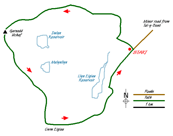
The walk starts at the end of a narrow steep gated lane from the village of Tal-y-Bont in the Vale of Conwy. The start of this lane is not sign posted but is situated left of the 'y Bedol' pub. Proceed up to the end of the lane (approx 3 miles) where there is limited parking (Grid ref SH 731 662).
Go over the stile at the north side of the parking area (not at the end of the lane) and proceed up the wide stoned track then right after the gate at the end. The easy to follow path at first descends then sweeps round left terminating at a dam and tunnel on the Pant y Granola (Grid ref SH 724 675). Cross over the bridge then over the left stile, a low building should be down on your right. Follow the feint path ahead gradually climbing then on reaching the stream, Afon Garreg-wen (Grid ref SH 718 675), turn right and follow its course up the steep hill, cross over the fence adjacent to a Sheepfold (Grid ref SH 715 676). Continue to follow the tumbling water to a gate, don't climb over, but with the fence on your left climb up to the stile (Grid ref SH 711 678).
Cross over the stile and bear right to join the contouring footpath that heads to the end of the valley ahead. It is very feint and at times not at all. If you have a GPS then set it to grid ref SH 6905 6725. Care must also be taken not to drop down the steep flanks on your left as there is a vertical drop to the unseen Dulyn Reservoir below. If in doubt head upwards. On reaching the previous grid reference take the very short climb left up to Garnedd Uchaf (Grid ref SH 687 669).
After a well deserved rest soaking in the spectacular views with the knowledge that it is down hill from now on, follow the southern footpath for a very short way towards Carnedd Llewelyn and look out for the feint path on your left (SH 688 665) that drops steeply down the flank heading south east. The path with its fantastic views of Cwm Eigiau descends to Llyn Eigiau (Grid ref SH 720 641). Keep to the wide path that skirts the right of the water passing the remote Hafod-y-rhiw farm with it's windmill. This was dammed as a reservoir, unfortunately the wall breached (still visible) on the 2nd November 1925 and the resulting flood caused sixteen deaths in the valley below. Keeping to this now wide track leads you back to your car.
Messaging & Social Media
Message Walking Britain and follow the latest news.

Mountain Weather
Stay safe on the mountains with detailed weather forecasts - for iOS devices or for Android devices.