Walk 1684 - printer friendly version
Lingmoor Fell & Langdale Walk
Author - Peter Smyly
Length - 7.0 miles / 11.4 km
Ascent - 1300 feet / 394 metres
Grade - easy/mod
Start - OS grid reference NY328047
Lat 54.4332570 + Long -3.0374614
Postcode LA22 9HW (approx. location only)
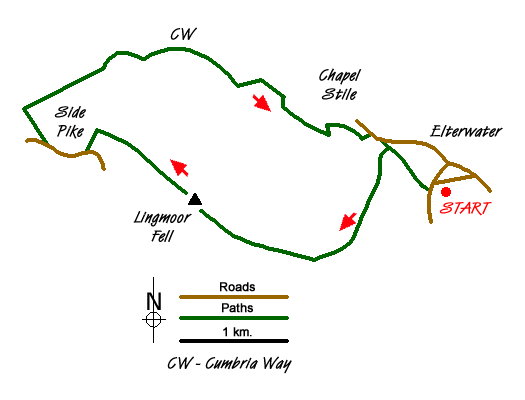
At 1,530 feet, Lingmoor Fell is less than half the height of Scafell Pike, England's highest mountain just a few miles away. As so often happens with an isolated peak, the quality of the views more than makes up for any lack of altitude. This Lake District walk starts at the village of Elterwater and by continuing on towards Side Pike, a circular route is made by coming back down the Great Langdale valley along part of the Cumbria Way. On a day when the cloud base is down to 2,000 feet, blotting out the main tops, a cloud-free walk can still be had. In good visibility it is the Langdale Pikes that dominate the view to the north. This is a walk that could be completed in a morning or an afternoon.
From Elterwater village, cross the bridge over the river and follow the minor road to the right with a sign for Chapel Stile in half a mile. Leave this road when a track appears on the right and follow it through woodland with the river on the right, passing piles of slate on the left. Follow the path as it goes round to the left and uphill to one of the quarries. Passing a deep quarry on the left, cross to the other side of the works area to reach public footpath signs indicating the way ahead with Lingmoor Fell, the main objective of today's walk seen beyond. Pass along an unsurfaced road leading to a tarmac road. Turn right along the road and then almost immediately take the next path leading uphill through woods on the left. After about fifty yards, at a crossroads of paths, take the one on the right and this leads up through and beyond woodland to follow a zig zag path up the open fellside as views of the Great Langdale valley open out with Chapel Stile nestling way below.
This track leads to the main ridge of Lingmoor Fell and the route bears right to follow the ups and downs of the ridge with a dry stone wall on the right before the little rocky summit is reached. Lingmoor Tarn, with its several flat islands, can be glimpsed below from the summit. The route continues along the crest of the ridge with Blea Tarn coming into view below on the left and the dome shape of Side Pike catching the eye below ahead. The route descends to the col in front of Side Pike before reaching the fence, and goes down steeply to reach a path leading off to the right through bracken which brings you to the dip between Side Pike and Pike O'Blisco. A sign indicates that a path to the right leads to the top of Side Pike in half a mile but for this route, with the Langdale Pikes dominating the view ahead, descend a steep stony path ahead to the foot of the hill. The track to the right leads all the way back down the Great Langdale valley and back to the walk's starting point.
Messaging & Social Media
Message Walking Britain and follow the latest news.

Mountain Weather
Stay safe on the mountains with detailed weather forecasts - for iOS devices or for Android devices.