Lingmoor Fell & Langdale from Elterwater
Lake District Walk
Nat Park - Lake District - Lake District Southern Fells
Wainwrights - Lingmoor Fell
County/Area - Cumbria
Author - Peter Smyly
Length - 7.0 miles / 11.4 km Ascent - 1300 feet / 394 metres
Time - 4 hours 50 minutes Grade - easy/mod
Walk Route Description
Click image to visit gallery of 6 images.
At 1,530 feet, Lingmoor Fell is less than half the height of Scafell Pike, England's highest mountain just a few miles away. As so often happens with an isolated peak, the quality of the views more than makes up for any lack of altitude. This Lake District walk starts at the village of Elterwater and by continuing on towards Side Pike, a circular route is made by coming back down the Great Langdale valley along part of the Cumbria Way. On a day when the cloud base is down to 2,000 feet, blotting out the main tops, a cloud-free walk can still be had. In good visibility it is the Langdale Pikes that dominate the view to the north. This is a walk that could be completed in a morning or an afternoon.
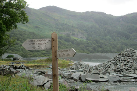
From Elterwater village, cross the bridge over the river and follow the minor road to the right with a sign for Chapel Stile in half a mile. Leave this road when a track appears on the right and follow it through woodland with the river on the right, passing piles of slate on the left. Follow the path as it goes round to the left and uphill to one of the quarries. Passing a deep quarry on the left, cross to the other side of the works area to reach public footpath signs indicating the way ahead with Lingmoor Fell, the main objective of today's walk seen beyond. Pass along an unsurfaced road leading to a tarmac road. Turn right along the road and then almost immediately take the next path leading uphill through woods on the left. After about fifty yards, at a crossroads of paths, take the one on the right and this leads up through and beyond woodland to follow a zig zag path up the open fellside as views of the Great Langdale valley open out with Chapel Stile nestling way below.
This track leads to the main ridge of Lingmoor Fell and the route bears right to follow the ups and downs of the ridge with a dry stone wall on the right before the little rocky summit is reached. Lingmoor Tarn, with its several flat islands, can be glimpsed below from the summit. The route continues along the crest of the ridge with Blea Tarn coming into view below on the left and the dome shape of Side Pike catching the eye below ahead. The route descends to the col in front of Side Pike before reaching the fence, and goes down steeply to reach a path leading off to the right through bracken which brings you to the dip between Side Pike and Pike O'Blisco. A sign indicates that a path to the right leads to the top of Side Pike in half a mile but for this route, with the Langdale Pikes dominating the view ahead, descend a steep stony path ahead to the foot of the hill. The track to the right leads all the way back down the Great Langdale valley and back to the walk's starting point.
Maps 

| Ordnance Survey Explorer OL6 | Sheet Map | 1:25k | BUY |
| Anquet OS Explorer OL6 | Digital Map | 1:25k | BUY |
| Ordnance Survey Digital Map Subscription | |||
| Latest Ordnance Survey Discounts | |||
Other walks nearby
| Walk 1141 | Elterwater circular | easy/mod | 4.0 miles |
| Walk 1059 | Colwith Force and Skelwith Force | easy/mod | 4.8 miles |
| Walk 1823 | Fairfield Horseshoe & Loughrigg from High Close | mod/hard | 14.0 miles |
| Walk 1134 | Wetherlam and The Carrs | mod/hard | 10.8 miles |
| Walk 2270 | Tilberthwaite and Holme Fell Little Langdale | easy/mod | 5.5 miles |
| Walk 3697 | Loughrigg Fell from Skelwith Bridge | easy/mod | 4.5 miles |
| Walk 1154 | Between Grasmere and Langdale | moderate | 9.5 miles |
| Walk 1472 | Alcock Tarn & Rydal Water | easy/mod | 7.0 miles |
| Walk 1565 | Rydal Water & Grasmere circular | easy/mod | 6.0 miles |
| Walk 1682 | Rydal Water & Grasmere | easy/mod | 5.5 miles |
Recommended Books & eBooks
Walking the Lake District Fells - Langdale
 Part of the Walking the Lake District Fells series, this guidebook covers a wide range of routes to 25 Lakeland summits that can be climbed from the Great Langdale valley, Ambleside and Grasmere, with highlights including Scafell Pike, Bowfell, the Langdale Pikes and Helm Crag (the Lion and the Lamb). Includes suggestions for longer ridge routes.
More information
The Cumbria Way
 A guidebook to the 73 mile Cumbria Way, an easy long-distance walk though the heart of the Lake District National Park, from Ulverston in the south to Carlisle in the north, with good transport links to either end. The route is largely low-level but this guide offers alternative mountain days to climb some of the famous fells en route.
More information
